IMAGES TAKEN NEAR TO
High Street, ST. IVES, TR26 1RS
Introduction
This page details the photographs taken nearby to High Street, TR26 1RS by members of the Geograph project.
The Geograph project started in 2005 with the aim of publishing, organising and preserving representative images for every square kilometre of Great Britain, Ireland and the Isle of Man.

There are currently over 7.5m images from over14,400 individuals and you can help contribute to the project by visiting https://www.geograph.org.uk
Image Map
Images are licensed for reuse under creativecommons.org/licenses/by-sa/2.0
Notes
- Clicking on the map will re-center to the selected point.
- The higher the marker number, the further away the image location is from the centre of the postcode.
Image Listing (843 Images Found)
Images are licensed for reuse under creativecommons.org/licenses/by-sa/2.0
Image
Details
Distance
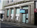
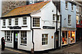
5
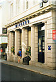
Midland Bank St Ives Cornwall 1997. Now HSBC
Image: © Roy Hughes
Taken: 8 Sep 1997
0.01 miles
7
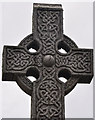
St Ives : War Memorial
The cross on the war memorial in St Ives.
Image: © Lewis Clarke
Taken: 16 Jul 2015
0.02 miles
8
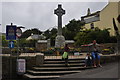
St Ives : War Memorial
A war memorial between St Andrews Street and the High Street.
Image: © Lewis Clarke
Taken: 16 Jul 2015
0.02 miles
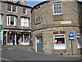
9
The corner of Fore Street and Lifeboat Hill, St Ives
Image: © Andy F
Taken: 17 Oct 2009
0.02 miles
10
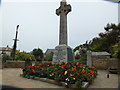
St Ives War Memorial
To the brave men and women who made the ultimate sacrifice.
Image: © Raymond Cubberley
Taken: 27 Jun 2012
0.02 miles