IMAGES TAKEN NEAR TO
Norway Square, ST. IVES, TR26 1NA
Introduction
This page details the photographs taken nearby to Norway Square, TR26 1NA by members of the Geograph project.
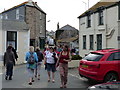
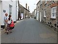
The Geograph project started in 2005 with the aim of publishing, organising and preserving representative images for every square kilometre of Great Britain, Ireland and the Isle of Man.

There are currently over 7.5m images from over14,400 individuals and you can help contribute to the project by visiting https://www.geograph.org.uk
Image Map
Images are licensed for reuse under creativecommons.org/licenses/by-sa/2.0
Notes
- Clicking on the map will re-center to the selected point.
- The higher the marker number, the further away the image location is from the centre of the postcode.
Image Listing (1089 Images Found)
Images are licensed for reuse under creativecommons.org/licenses/by-sa/2.0
Image
Details
Distance
2
The St Ives Society of Artists' gallery
The gallery uses the former Anglican chapel of St Nicholas, built in 1905, but only used until the 1940s
Image: © David Smith
Taken: 17 Jan 2014
0.01 miles
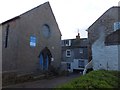
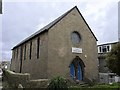
3
Former Bible Christian chapel
Marked as Methodist Church Hall.
Image: © Paul Barnett
Taken: 22 Mar 2015
0.01 miles
4
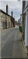
Back Road East
A narrow road near to the sea in St Ives.
Image: © Oscar Taylor
Taken: 6 Sep 2020
0.01 miles
5
Back Street West
Looking towards the St Ives School of Painting, up the stairs.
Image: © Raymond Cubberley
Taken: 27 Jun 2012
0.01 miles
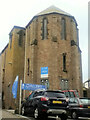
6
St Ives Society of Artists
Housed in the Former Mariners' Church. Grade II listed. Listing number 1396301. Built in 1903-05 in memory of Canon John Balmer-Jonesto to a design by Edmund Harold Sedding (1863-1921) by Robert Toy of St Ives.
Image: © Andrew Abbott
Taken: 19 Nov 2017
0.01 miles
7
St Ives Society of Artists Gallery (formerly Mariners' Church)
Image: © Paul Barnett
Taken: 1 Jan 2014
0.01 miles
8
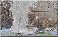
Ordnance Survey Cut Mark
This OS cut mark can be found on No21 Back Row. It marks a point 13.1936m above mean sea level.
Image: © Adrian Dust
Taken: 21 Feb 2017
0.01 miles
9
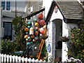
Norway House - St Ives
This old fisherman's cottage in a quiet corner high above the Sloop Inn and harbour is now a Bed & Breakfast.
Image: © Sarah Smith
Taken: 12 Apr 2010
0.02 miles
10
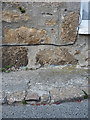
OS benchmark - St Ives, Back Road West
An OS cutmark low on the frontage of a building on Back Road West; originally levelled in 1953 at 13.194m above Ordnance Datum Newlyn.
Image: © Richard Law
Taken: 12 Oct 2015
0.02 miles