IMAGES TAKEN NEAR TO
Lifeboat Hill, ST. IVES, TR26 1LE
Introduction
This page details the photographs taken nearby to Lifeboat Hill, TR26 1LE by members of the Geograph project.
The Geograph project started in 2005 with the aim of publishing, organising and preserving representative images for every square kilometre of Great Britain, Ireland and the Isle of Man.

There are currently over 7.5m images from over14,400 individuals and you can help contribute to the project by visiting https://www.geograph.org.uk
Image Map
Images are licensed for reuse under creativecommons.org/licenses/by-sa/2.0
Notes
- Clicking on the map will re-center to the selected point.
- The higher the marker number, the further away the image location is from the centre of the postcode.
Image Listing (953 Images Found)
Images are licensed for reuse under creativecommons.org/licenses/by-sa/2.0
Image
Details
Distance
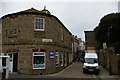
1
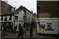
Shops and ghost-sign on Lifeboat Hill, St Ives
The ghost-sign can be seen closer at Image
Image: © Christopher Hilton
Taken: 8 Apr 2016
0.01 miles
2
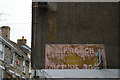
Ghost-sign, Lifeboat Hill, St Ives
This sign possibly represents two layers: the pale writing advertising Picture Post does not seem to mesh completely with the darker writing, which may indicate that multiple signs were painted onto this site over the years.
The sign can be seen in context at Image
Image: © Christopher Hilton
Taken: 8 Apr 2016
0.01 miles
3
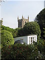
St Ives church seen from Barbara Hepworth's studio
Image: © Rod Allday
Taken: 10 May 2008
0.01 miles
4
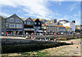
Wharf Road, St Ives
View from the Pier.
Image: © Pierre Terre
Taken: 23 Jul 2008
0.01 miles
5
Market Place and Market House, St Ives
The ghost-sign in the distance, above the van, can be seen closer at Image
Image: © Christopher Hilton
Taken: 8 Apr 2016
0.01 miles
7
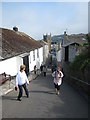
Looking down Barnoon Hill towards St Ives church
Image: © Rod Allday
Taken: 10 May 2008
0.01 miles
8
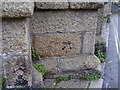
Cut Benchmark and bolt
On the base of the tower to the parish church.
Image: © Anthony Vosper
Taken: 1 May 2011
0.01 miles
9
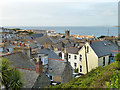
View over St. Ives
Featuring the square tower of St. Ives parish church (dedicated to St. Ia, St. Andrew and St. Peter), to its left the tower of the United Methodist Community Church and in front of that tower the large square hipped roof of the former Wesleyan chapel, now a theatre. Immediately adjacent to its right is the former Wesleyan school, now a backpackers' hostel.
Image: © Robin Webster
Taken: 16 May 2013
0.01 miles
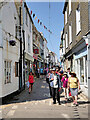
10
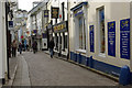
Fore Street, St Ives
Narrow cobbled street, running just behind the harbour front, typical of a Cornish seaside town.
Image: © Stephen McKay
Taken: 24 Mar 2009
0.01 miles