IMAGES TAKEN NEAR TO
Fore Street, ST. IVES, TR26 1HW
Introduction
This page details the photographs taken nearby to Fore Street, TR26 1HW by members of the Geograph project.
The Geograph project started in 2005 with the aim of publishing, organising and preserving representative images for every square kilometre of Great Britain, Ireland and the Isle of Man.

There are currently over 7.5m images from over14,400 individuals and you can help contribute to the project by visiting https://www.geograph.org.uk
Image Map
Images are licensed for reuse under creativecommons.org/licenses/by-sa/2.0
Notes
- Clicking on the map will re-center to the selected point.
- The higher the marker number, the further away the image location is from the centre of the postcode.
Image Listing (1014 Images Found)
Images are licensed for reuse under creativecommons.org/licenses/by-sa/2.0
Image
Details
Distance
1
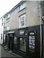
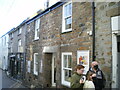
75 Fore Street, St Ives
Now trading as an off-licence outlet for alcohol sales, no 75 Fore Street is described as "An early 19th century fronting to a building of probable earlier origin" in its 1972 Grade II listing details https://britishlistedbuildings.co.uk/101327759-75-fore-street-st-ives#.YeCoHv7P3IU & https://historicengland.org.uk/listing/the-list/list-entry/1327759 It was most likely built as cottages or a house.
Image: © Richard Law
Taken: 23 Dec 2021
0.00 miles
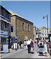
2
Fore Street Methodist Church, St Ives
The former Primitive Methodist Church (see: http://en.wikipedia.org/wiki/Primitive_Methodism ), built in 1831. The "Primitives" merged with the mainstream Methodist movement in 1932, but the building still bears the Primitive Methodist Church title. The narrow streets of St Ives are typically busy with tourists on a summer day.
Image: © Bill Harrison
Taken: 20 Jul 2012
0.00 miles
3
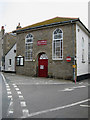
Bible Christian Chapel, St Ives
In St Peters Street.
Image: © Pauline E
Taken: 25 Apr 2008
0.00 miles
4
Fore Street Methodist Church
The rather rugged stonework as seen from Wharf Road. The Fore Street frontage (see: http://www.geograph.org.uk/photo/3318608 ) is whitewashed.
Image: © Bill Harrison
Taken: 20 Jul 2012
0.01 miles
5
71 & 73 Fore Street, St Ives
Although the frontage looks like a single former house, the address is given as nos 71 and 73, which is actually a pair of mid 19th century cottages with a twin entrance just inside the street-facing doorway. They are now in use as a small art gallery, and were Grade II listed https://britishlistedbuildings.co.uk/101312628-71-and-73-fore-street-st-ives#.YdjBLf7P3IU & https://historicengland.org.uk/listing/the-list/list-entry/1312628 in 1972.
Image: © Richard Law
Taken: 23 Dec 2021
0.01 miles
6
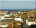
St Ives rooftops
Godrevy Island and its lighthouse are in the distance. The pure air is evidenced by the prolific lichen growth on the rooftops.
Image: © Rod Allday
Taken: 14 Oct 2017
0.01 miles

9
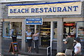
St Ives : Beach Restaurant
A place to get traditional fish and chips and eat them beside the harbour.
Image: © Lewis Clarke
Taken: 2 Jul 2011
0.01 miles
10
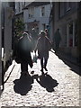
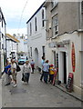
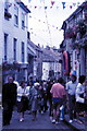
St. Ives: walking up Fore Street
Two ladies walk up the northern end of Fore Street, one of the main thoroughfares in the town.
Image: © Chris Downer
Taken: 14 Oct 2013
0.01 miles