IMAGES TAKEN NEAR TO
Court Cocking, ST. IVES, TR26 1HQ
Introduction
This page details the photographs taken nearby to Court Cocking, TR26 1HQ by members of the Geograph project.
The Geograph project started in 2005 with the aim of publishing, organising and preserving representative images for every square kilometre of Great Britain, Ireland and the Isle of Man.

There are currently over 7.5m images from over14,400 individuals and you can help contribute to the project by visiting https://www.geograph.org.uk
Image Map
Images are licensed for reuse under creativecommons.org/licenses/by-sa/2.0
Notes
- Clicking on the map will re-center to the selected point.
- The higher the marker number, the further away the image location is from the centre of the postcode.
Image Listing (996 Images Found)
Images are licensed for reuse under creativecommons.org/licenses/by-sa/2.0
Image
Details
Distance
1
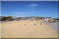
St Ives Harbour
The harbour at low tide, seen from the end of the pier.
Image: © Pierre Terre
Taken: 23 Jul 2008
0.01 miles
2
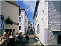
The Digey, St Ives
The southern end of the Digey, at Fore Street.
Image: © Pierre Terre
Taken: 23 Jul 2008
0.01 miles
4
The Hobblers Restaurant
Another fine eating house tucked away
Image: © Raymond Cubberley
Taken: 27 Jun 2012
0.01 miles
5
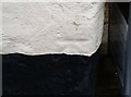
Ordnance Survey Cut Mark
This OS cut mark can be found on the Court Arcade. It marks a point 5.1761m above mean sea level.
Image: © Adrian Dust
Taken: 21 Feb 2017
0.01 miles
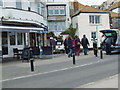
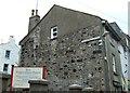
6
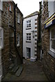
Court Cocking, off Fore Street, St Ives
Image: © Christopher Hilton
Taken: 8 Apr 2016
0.01 miles
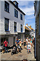
7
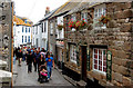
Visitors strolling in Fore Street, St Ives
Looking north along Fore Street. For another view in this area see [http://www.geograph.org.uk/photo/310230] .
Image: © Andy F
Taken: 18 Oct 2009
0.01 miles
8
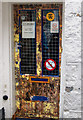
A colourful shop door on Fore Street, St Ives
Image: © Andy F
Taken: 18 Oct 2009
0.01 miles
9

Cobbled street surface on Fore Street, looking north
Part of the extensive granite cobbled street surface of Fore Street, which dates back probably to the 18th century, and was Grade II listed https://britishlistedbuildings.co.uk/101143372-the-street-surface-st-ives#.YeRDX_7P3IU & https://historicengland.org.uk/listing/the-list/list-entry/1143372 in 1972.
Image: © Richard Law
Taken: 23 Dec 2021
0.01 miles
10
Salubrious Place, St Ives
And so it should be too as home to the Zion Congregational Church [Countess of Huntingdon's Connexion] and all.
Old St Ives has a number of interesting and unusual street names - in this case it would be interesting to know what came first, the chapel or the name?
The original chapel of what would become the 'Countess of Huntingdon's Connexion'[sic] was founded in 1761 by Selina Shirley, Countess of Huntingdon, in North Street Brighton. She is reputed to have paid for the chapel by selling her jewellery.
The Calvinistic Methodist George Whitefield was her first preacher and the chapel was so successful that by the time the Countess died in 1791 several other chapels had also opened throughout the country including ones at Bath and Worcester.
Image: © Simon Huguet
Taken: 11 Aug 2008
0.01 miles