IMAGES TAKEN NEAR TO
Wheal Ayr Court, ST. IVES, TR26 1EG
Introduction
This page details the photographs taken nearby to Wheal Ayr Court, TR26 1EG by members of the Geograph project.
The Geograph project started in 2005 with the aim of publishing, organising and preserving representative images for every square kilometre of Great Britain, Ireland and the Isle of Man.

There are currently over 7.5m images from over14,400 individuals and you can help contribute to the project by visiting https://www.geograph.org.uk
Image Map
Images are licensed for reuse under creativecommons.org/licenses/by-sa/2.0
Notes
- Clicking on the map will re-center to the selected point.
- The higher the marker number, the further away the image location is from the centre of the postcode.
Image Listing (79 Images Found)
Images are licensed for reuse under creativecommons.org/licenses/by-sa/2.0
Image
Details
Distance
5
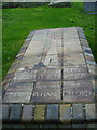
The Grave of Alfred Wallis
St Ives cemetery is the burial place of local artist Alfred Wallis whose 'Naive' paintings are now highly sought after.
Image: © Malcolm Reid
Taken: 11 Sep 2006
0.09 miles
7
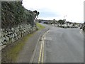
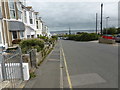
Housing estate, edge of St Ives
Channel View, leading to Carthew Way and Orange Lane
Image: © David Smith
Taken: 12 Mar 2016
0.10 miles
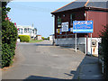
8
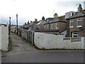
The service lane for houses in Channel View and Alexandra Road
Image: © David Smith
Taken: 12 Mar 2016
0.12 miles
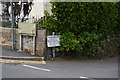
10
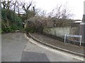
Footpath to the coast from Carthew Close, St Ives
A narrow path leads from here to the coast, first between fences and then across scrubland
Image: © David Smith
Taken: 12 Mar 2016
0.13 miles