IMAGES TAKEN NEAR TO
Veryan, TRURO, TR2 5UW
Introduction
This page details the photographs taken nearby to TR2 5UW by members of the Geograph project.
The Geograph project started in 2005 with the aim of publishing, organising and preserving representative images for every square kilometre of Great Britain, Ireland and the Isle of Man.

There are currently over 7.5m images from over14,400 individuals and you can help contribute to the project by visiting https://www.geograph.org.uk
Image Map
Images are licensed for reuse under creativecommons.org/licenses/by-sa/2.0
Notes
- Clicking on the map will re-center to the selected point.
- The higher the marker number, the further away the image location is from the centre of the postcode.
Image Listing (11 Images Found)
Images are licensed for reuse under creativecommons.org/licenses/by-sa/2.0
Image
Details
Distance
1
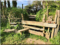
Stone Stile, Veryan
Looking from the field on Cornwall footpath 327/46/1, the view from the road is Image
Image: © Jayne Tovey
Taken: 2 Aug 2023
0.19 miles
2
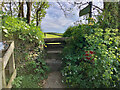
Stone Stile, Veryan
Looking from the road on Cornwall footpath 327/46/1, the view from the field is Image
Image: © Jayne Tovey
Taken: 2 Aug 2023
0.19 miles
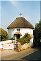
3
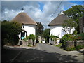
Veryan Round Houses
Five of these unusual houses were constructed in the village in the 1820's. It is said that they were built round "so that the devil cannot hide in the corners".
Image: © Tony Atkin
Taken: 15 Aug 2005
0.21 miles
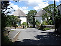
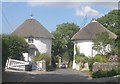
6
Round houses - Veryan
Two of the round houses that this Cornish village is well known for.
Image: © Chris Allen
Taken: 22 Apr 2014
0.21 miles
7
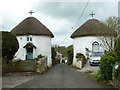
Chyrond and Round House East, Veryan
Two Grade II* Listed round cottages built between 1815 and 1818 reputedly inspired by one in St Winnow. One of 5 round houses built in Veryan by Hugh Rowe, a Lostwithiel builder, for the Reverend Jeremiah Trist (1755-1829). Trist added the church clock tower and also had two schools and Parc Behan built (In 1870-72 John Marius Wilson says the church was rebuilt in 1848). Reportedly built for his five daughters, it seems they were lived in by his tenants or labourers of the village. Trist had five daughters and two sons but by 1815 Louisa had died and Maria died in 1818.
Image: © Jo and Steve Turner
Taken: 11 Jun 2005
0.21 miles
8
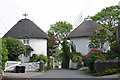
Veryan - Chyrond & East Round House
Two of the five famous Round Houses in the village of Veryan. Dating from c.1820 the house on the left is called Chyrond, while that on the right is East Round House.
See also Image]
They are both EH Grade II* listed
Chyrond: https://historicengland.org.uk/listing/the-list/list-entry/1219588?section=official-list-entry
East Round House: https://historicengland.org.uk/listing/the-list/list-entry/1291400?section=official-list-entry
Image: © Rob Farrow
Taken: 3 Aug 2024
0.21 miles
9
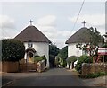
Veryan round houses
Two of 5 round houses in Veryan built by Hugh Rowe, a Lostwithiel builder for the Reverend Jeremiah Trist, reputed to be one for each of his 5 daughters. The round plan is said to be to deter the activities of the Devil because he has no corners in which to hide, but the more likely reason is economy of construction. Grade II* listed: http://www.imagesofengland.org.uk/Details/Default.aspx?id=393625&mode=adv and http://www.imagesofengland.org.uk/Details/Default.aspx?id=393626&mode=adv
Image: © Rod Allday
Taken: 4 Sep 2009
0.21 miles
10
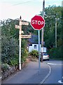
Old Direction Sign - Signpost by Elerkey Lane, Veryan parish
Pyramid finial - 4 arms; 'Visick' by the UC road, in parish of Veryan (Carrick District), Elerkey Lane junction with Green Lane and Tollyfrank Hill, at back of footpath.
Surveyed
Milestone Society National ID: CW_SW9139B
Image: © Milestone Society
Taken: Unknown
0.24 miles