IMAGES TAKEN NEAR TO
Pen Brea Close, TRURO, TR2 5UN
Introduction
This page details the photographs taken nearby to Pen Brea Close, TR2 5UN by members of the Geograph project.
The Geograph project started in 2005 with the aim of publishing, organising and preserving representative images for every square kilometre of Great Britain, Ireland and the Isle of Man.

There are currently over 7.5m images from over14,400 individuals and you can help contribute to the project by visiting https://www.geograph.org.uk
Image Map
Images are licensed for reuse under creativecommons.org/licenses/by-sa/2.0
Notes
- Clicking on the map will re-center to the selected point.
- The higher the marker number, the further away the image location is from the centre of the postcode.
Image Listing (10 Images Found)
Images are licensed for reuse under creativecommons.org/licenses/by-sa/2.0
Image
Details
Distance
1
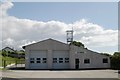
St Mawes fire station
St Mawes fire station, Polvarth Road, St Mawes, Cornwall
Image: © Kevin Hale
Taken: 8 Jul 2007
0.04 miles
2
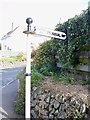
Old Direction Sign - Signpost by the A3078, Polvarth Road, St Mawes
Ball finial - 1 arm; Holman casting by the A3078, in parish of St Just in Roseland (Carrick District), by Polvarth Estate turn in St Mawes, at back of footpath, against garden wall of Gwelesmor House.
Surveyed
Milestone Society National ID: CW_SW8533
Image: © Milestone Society
Taken: Unknown
0.08 miles
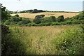
4
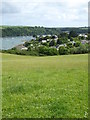
Field above the Percuil River
Looking towards Image in the far distance.
Image: © Rod Allday
Taken: 12 Jun 2016
0.19 miles
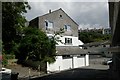
5
Valley, St Mawes
A valley that in effect bisects St Mawes, emerging at The Square on the seafront. Seen here from the A3078 Polvarth Road.
Image: © Derek Harper
Taken: 19 Jul 2016
0.19 miles
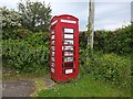
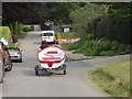
6
Reserved for gigs, St Mawes
Unusual reserved parking bays at the summit of the car park in St Mawes. Behind is a pumping station.
Image: © Derek Harper
Taken: 19 Jul 2016
0.21 miles
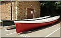
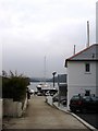
8
Public Footpath, Porthcuel Creek, St Mawes Boatyard
The footpath has been routed around the rear of a building, but it is gravelled and well kept, complete with sign
Image: © Tom Jolliffe
Taken: 25 Mar 2007
0.24 miles
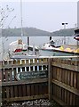
9
Boatyard, St Mawes, Cornwall
The distant view is of Pelyn Creek from the entrance road to the boatyard at St Mawes
Image: © Tom Jolliffe
Taken: 25 Mar 2007
0.24 miles
10
St Mawes old fire station
St Mawes old fire station, Bohella Road, St Mawes, Cornwall, now converted into a shop.
Image: © Kevin Hale
Taken: 8 Jul 2007
0.24 miles