IMAGES TAKEN NEAR TO
Tregony, TRURO, TR2 5UF
Introduction
This page details the photographs taken nearby to TR2 5UF by members of the Geograph project.
The Geograph project started in 2005 with the aim of publishing, organising and preserving representative images for every square kilometre of Great Britain, Ireland and the Isle of Man.

There are currently over 7.5m images from over14,400 individuals and you can help contribute to the project by visiting https://www.geograph.org.uk
Image Map
Images are licensed for reuse under creativecommons.org/licenses/by-sa/2.0
Notes
- Clicking on the map will re-center to the selected point.
- The higher the marker number, the further away the image location is from the centre of the postcode.
Image Listing (10 Images Found)
Images are licensed for reuse under creativecommons.org/licenses/by-sa/2.0
Image
Details
Distance
1
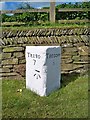
Old Milestone by the A3078, Grogoth Wallas
Carved stone post by the A3078, in parish of TREGONEY (CARRICK District), Grogoth Wallas, by turn signed Cornelly Church, by the road, on West side of road. Tregony stone, erected by the Creed & St Just turnpike trust in the 19th century.
Inscription reads:-
: TRURO / 7 : : TREGONY / ½ :
Carved benchmark on side face.
Grade II Listed. List Entry Number:1396127
https://historicengland.org.uk/listing/the-list/list-entry/1396127
Milestone Society National ID: CW_TOTG07.
Image: © Ian Thompson
Taken: 1 Jan 1998
0.02 miles
2

Old Milestone by the A3078, Grogoth Wallas
Carved stone post by the A3078, in parish of TREGONEY (CARRICK District), Grogoth Wallas, by turn signed Cornelly Church, by the road, on West side of road. Tregony stone, erected by the Creed & St Just turnpike trust in the 19th century.
Inscription reads:-
: TRURO / 7 : : TREGONY / ½ :
Carved benchmark on left side face.
Grade II listed.
List Entry Number: 1396127 https://historicengland.org.uk/listing/the-list/list-entry/1396127
Milestone Society National ID: CW_TOTG07.
Image: © Rosy Hanns
Taken: 24 May 2019
0.02 miles
3
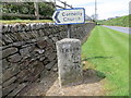
Ordnance Survey Cut Mark
This mark can be found on the milestone at Grogoth Wallas. The benchmark height is recorded as being 195.1 feet above sea level.
For more detail see : http://www.bench-marks.org.uk/bm85774
Image: © Peter Wood
Taken: 5 May 2017
0.03 miles
4
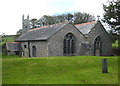
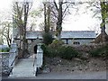
The church of St Cornelius at Cornelly
The parish of Cornelly has a church but no village. The church dates from the C13, with C15 additions.
Image: © Rod Allday
Taken: 4 Sep 2009
0.04 miles
5
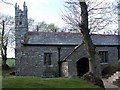
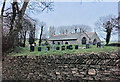
The Church of Cornelius at Cornelly
Viewed from the south-east. The church somehow seems to be located with Grogoth Wallas.
Image: © Peter Wood
Taken: 5 May 2017
0.05 miles
6
Cornelly Church.
Built in the 13th century within an Iron Age enclosure.
Image: © Fred James
Taken: 22 Apr 2007
0.05 miles
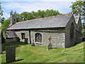
9
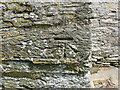
Ordnance Survey Cut Mark
This mark can be found on the wall of St Cornelius Church at Grogoth Wallas. The benchmark height is recorded as being 55.321 metres above sea level.
For more detail see : http://www.bench-marks.org.uk/bm85773
Image: © Peter Wood
Taken: 5 May 2017
0.06 miles
10
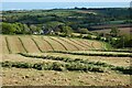
Farmland, Tregpny
Cut silage on the hillside above Grogoth Wallas and Cornelly church.
Image: © Andrew Smith
Taken: 12 May 2022
0.11 miles