IMAGES TAKEN NEAR TO
Cuby Road, TRURO, TR2 5TN
Introduction
This page details the photographs taken nearby to Cuby Road, TR2 5TN by members of the Geograph project.
The Geograph project started in 2005 with the aim of publishing, organising and preserving representative images for every square kilometre of Great Britain, Ireland and the Isle of Man.

There are currently over 7.5m images from over14,400 individuals and you can help contribute to the project by visiting https://www.geograph.org.uk
Image Map
Images are licensed for reuse under creativecommons.org/licenses/by-sa/2.0
Notes
- Clicking on the map will re-center to the selected point.
- The higher the marker number, the further away the image location is from the centre of the postcode.
Image Listing (24 Images Found)
Images are licensed for reuse under creativecommons.org/licenses/by-sa/2.0
Image
Details
Distance
1
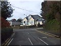
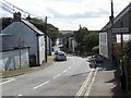
Speed humps before a bend on the east of Tregony
The road on the right leads to the village church
Image: © David Smith
Taken: 31 Jan 2013
0.01 miles
6
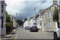
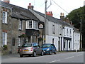
The B3287
The B 3287 is also Tregony's main street.
Image: © Robert Ashby
Taken: 19 Aug 2014
0.09 miles
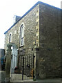
7
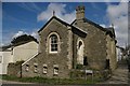
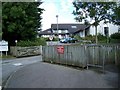
Tregony: former school
This is the former Wesleyan (Methodist) Sunday School Building): erected in 1883, it was used up until the early 1990s. It was sold off in 1994 and became a private dwelling.
[Information courtesy of Frank Grigg]
Image: © Christopher Hilton
Taken: 17 Apr 2009
0.14 miles