IMAGES TAKEN NEAR TO
Tregony, TRURO, TR2 5SX
Introduction
This page details the photographs taken nearby to TR2 5SX by members of the Geograph project.
The Geograph project started in 2005 with the aim of publishing, organising and preserving representative images for every square kilometre of Great Britain, Ireland and the Isle of Man.

There are currently over 7.5m images from over14,400 individuals and you can help contribute to the project by visiting https://www.geograph.org.uk
Image Map
Images are licensed for reuse under creativecommons.org/licenses/by-sa/2.0
Notes
- Clicking on the map will re-center to the selected point.
- The higher the marker number, the further away the image location is from the centre of the postcode.
Image Listing (6 Images Found)
Images are licensed for reuse under creativecommons.org/licenses/by-sa/2.0
Image
Details
Distance
1
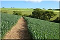
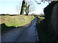
Farmland, Veryan
A well reinstated footpath is a slight novelty in Cornwall, so this is a pleasant sight to the south of Trencreek.
Image: © Andrew Smith
Taken: 12 May 2022
0.16 miles
4
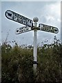
Old Direction Sign - Signpost in Tippetts Shop, Veryan Parish
Ball finial - one plastic arm; Holman casting by the UC road, in parish of Veryan (Carrick District), opposite houses at Tippetts Shop, in Y of junction.
Surveyed
Milestone Society National ID: CW_SW9342B
Image: © Milestone Society
Taken: Unknown
0.23 miles
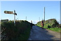
5
National Cycle Route 3, Tippetts Shop
Heading east.
Image: © JThomas
Taken: 5 Nov 2014
0.23 miles
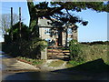
6
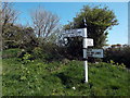
Old road sign near Tippetts shop
Old style road sign at junction near Tippetts shop.
Image: © Dean Jenkins
Taken: 18 Apr 2014
0.25 miles