IMAGES TAKEN NEAR TO
Tregony, TRURO, TR2 5SP
Introduction
This page details the photographs taken nearby to TR2 5SP by members of the Geograph project.
The Geograph project started in 2005 with the aim of publishing, organising and preserving representative images for every square kilometre of Great Britain, Ireland and the Isle of Man.

There are currently over 7.5m images from over14,400 individuals and you can help contribute to the project by visiting https://www.geograph.org.uk
Image Map
Images are licensed for reuse under creativecommons.org/licenses/by-sa/2.0
Notes
- Clicking on the map will re-center to the selected point.
- The higher the marker number, the further away the image location is from the centre of the postcode.
Image Listing (8 Images Found)
Images are licensed for reuse under creativecommons.org/licenses/by-sa/2.0
Image
Details
Distance
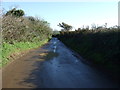
2
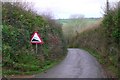
Steep road to Tubbs Mill
The chevrons on the road are the most notable feature on the map of this square - and this is the sign which warns you of the same hill.
Image: © Kieran Evans
Taken: 30 Dec 2006
0.22 miles
5
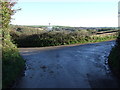
Minor road junction near Tubbs Mill
Turn right for National Cycle Route 3.
Image: © JThomas
Taken: 5 Nov 2014
0.24 miles
7
National Cycle Route 3
Lane heading east towards Tubbs Mill.
Image: © JThomas
Taken: 5 Nov 2014
0.25 miles