IMAGES TAKEN NEAR TO
Tregony, TRURO, TR2 5SH
Introduction
This page details the photographs taken nearby to TR2 5SH by members of the Geograph project.
The Geograph project started in 2005 with the aim of publishing, organising and preserving representative images for every square kilometre of Great Britain, Ireland and the Isle of Man.

There are currently over 7.5m images from over14,400 individuals and you can help contribute to the project by visiting https://www.geograph.org.uk
Image Map
Images are licensed for reuse under creativecommons.org/licenses/by-sa/2.0
Notes
- Clicking on the map will re-center to the selected point.
- The higher the marker number, the further away the image location is from the centre of the postcode.
Image Listing (3 Images Found)
Images are licensed for reuse under creativecommons.org/licenses/by-sa/2.0
Image
Details
Distance
1
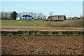
Farmland, St Ewe
Arable fields and pasture to the south of Pencoise.
Image: © Andrew Smith
Taken: 20 Jan 2020
0.06 miles
2
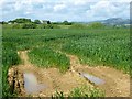
Farmland, St Ewe
A cereal crop with Pencoise in the background.
Image: © Andrew Smith
Taken: 5 Jun 2014
0.19 miles
3
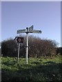
Old Direction Sign - Signpost near Vose, St Ewe Parish
Ball finial - Serrated arm tops, barley twist and fluted column; Charlestown casting, by the UC road, in parish of St Ewe (Restormel District), Vose, turn to Polmassick, on grass verge near Vose Farm.
Grade II Listed. List Entry Number: 1136914
https://historicengland.org.uk/listing/the-list/list-entry/1136914
Surveyed
Milestone Society National ID: CW_SW9646
Image: © Milestone Society
Taken: Unknown
0.23 miles