IMAGES TAKEN NEAR TO
Tregony, TRURO, TR2 5SF
Introduction
This page details the photographs taken nearby to TR2 5SF by members of the Geograph project.
The Geograph project started in 2005 with the aim of publishing, organising and preserving representative images for every square kilometre of Great Britain, Ireland and the Isle of Man.

There are currently over 7.5m images from over14,400 individuals and you can help contribute to the project by visiting https://www.geograph.org.uk
Image Map
Images are licensed for reuse under creativecommons.org/licenses/by-sa/2.0
Notes
- Clicking on the map will re-center to the selected point.
- The higher the marker number, the further away the image location is from the centre of the postcode.
Image Listing (4 Images Found)
Images are licensed for reuse under creativecommons.org/licenses/by-sa/2.0
Image
Details
Distance
1
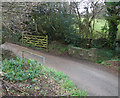
Bridge/Culvert on a very minor road
Culvert/bridge on a very minor stream that passes between two farms at the end of a very minor road that turns into a private road
Image: © Mike Lyne
Taken: 21 Jan 2012
0.08 miles
2
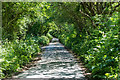
Sun dappled country lane
On the unclassified narrow country lane (Creed Lane) between Grampound and its junction with the B3827 from Hewas Water to Tregony is this 'tunnel' of trees and undergrowth totally enveloping the road but it looks nice in the dappled sunlight.
Image: © Mike Lyne
Taken: 20 Jun 2020
0.17 miles
3
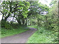
Byway to Golden Mill
Oak trees at their best for photographing; not too dark.
Image: © Jonathan Billinger
Taken: 9 May 2007
0.20 miles
4
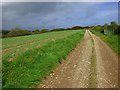
Farmland, Cuby
Spring-sown cereal and the byroad from Golden Mill.
Image: © Andrew Smith
Taken: 8 May 2019
0.22 miles