IMAGES TAKEN NEAR TO
Lords Meadow, TRURO, TR2 5RZ
Introduction
This page details the photographs taken nearby to Lords Meadow, TR2 5RZ by members of the Geograph project.
The Geograph project started in 2005 with the aim of publishing, organising and preserving representative images for every square kilometre of Great Britain, Ireland and the Isle of Man.

There are currently over 7.5m images from over14,400 individuals and you can help contribute to the project by visiting https://www.geograph.org.uk
Image Map
Images are licensed for reuse under creativecommons.org/licenses/by-sa/2.0
Notes
- Clicking on the map will re-center to the selected point.
- The higher the marker number, the further away the image location is from the centre of the postcode.
Image Listing (21 Images Found)
Images are licensed for reuse under creativecommons.org/licenses/by-sa/2.0
Image
Details
Distance
7
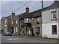
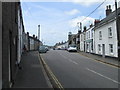
Cuby: Tregony
The main street looking north east. Tregony was at the head of a navigable river in medieval times – with a market – but the Fal became badly silted due to tin streaming and its sea-born trade went to Truro
Image: © Martin Bodman
Taken: Unknown
0.13 miles
10
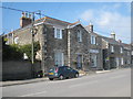
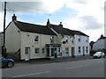
The Old Town Hall Tregony
Now an antiques shop, this imposing building gives an indication of the town's former importance when it was a market town and a port on the River Fal. The Fal silted up long ago as a result of tin streaming works and with the loss of the port, the town declined in importance. More details of this Grade II listed building here: http://www.imagesofengland.org.uk/Details/Default.aspx?id=62918&mode=adv
Image: © Rod Allday
Taken: 19 Apr 2009
0.14 miles