IMAGES TAKEN NEAR TO
Portloe, TRURO, TR2 5PT
Introduction
This page details the photographs taken nearby to TR2 5PT by members of the Geograph project.
The Geograph project started in 2005 with the aim of publishing, organising and preserving representative images for every square kilometre of Great Britain, Ireland and the Isle of Man.

There are currently over 7.5m images from over14,400 individuals and you can help contribute to the project by visiting https://www.geograph.org.uk
Image Map
Images are licensed for reuse under creativecommons.org/licenses/by-sa/2.0
Notes
- Clicking on the map will re-center to the selected point.
- The higher the marker number, the further away the image location is from the centre of the postcode.
Image Listing (8 Images Found)
Images are licensed for reuse under creativecommons.org/licenses/by-sa/2.0
Image
Details
Distance
1
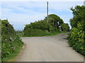
Junction of Road and Bridleway near Tregenna
Looking north-eastward.
Image: © Peter Wood
Taken: 5 May 2017
0.15 miles

3
Coast path, Veryan
Looking towards the footbridge in https://www.geograph.org.uk/photo/2028626 between Portholland and Portloe.
Image: © Andrew Smith
Taken: 14 May 2018
0.17 miles
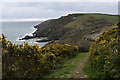
4
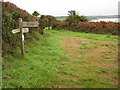
On the South West Coast Path
Footpath sign on the South West Coast Path to the west of West Portholland.
Image: © Philip Halling
Taken: 30 Sep 2010
0.18 miles
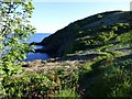
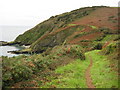
6
View from the South West Coast Path, looking south
Image: © Rob Purvis
Taken: 11 Sep 2010
0.20 miles
7
Coast path near West Portholland
South West Coast Path to the west of West Portholland.
Image: © Philip Halling
Taken: 30 Sep 2010
0.20 miles
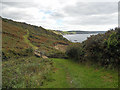
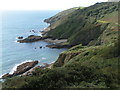
8
The South West Coast Path above Catchole Beach
Looking south-west, with the small coves of Great and Little Perlea just visible.
Image: © Simon Mortimer
Taken: 7 Apr 2019
0.22 miles