IMAGES TAKEN NEAR TO
Veryan, TRURO, TR2 5PP
Introduction
This page details the photographs taken nearby to TR2 5PP by members of the Geograph project.
The Geograph project started in 2005 with the aim of publishing, organising and preserving representative images for every square kilometre of Great Britain, Ireland and the Isle of Man.

There are currently over 7.5m images from over14,400 individuals and you can help contribute to the project by visiting https://www.geograph.org.uk
Image Map
Images are licensed for reuse under creativecommons.org/licenses/by-sa/2.0
Notes
- Clicking on the map will re-center to the selected point.
- The higher the marker number, the further away the image location is from the centre of the postcode.
Image Listing (8 Images Found)
Images are licensed for reuse under creativecommons.org/licenses/by-sa/2.0
Image
Details
Distance
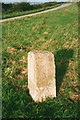
1
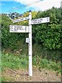
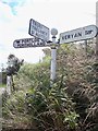
Old Direction Sign - Signpost near Crohans, Veryan parish
Pyramid spear finial - 3 arms; Cornwall CC iron spear by the UC road, in parish of Veryan (Carrick District), Crohans, next to lay-by, on verge 2m from road. Just South of Guide Stone: CW_XVER1 Image
Surveyed
Milestone Society National ID: CW_SW9341B
Image: © Milestone Society
Taken: Unknown
0.12 miles
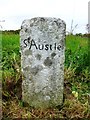
2
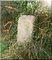
Old Guide Stone at Crohans, Veryan parish
Carved stone post South East of the A4078, in parish of VERYAN (CARRICK District), Crohans, in the angle of the road fork, on open grass verge, on North side of road. Erected by the parish in the 19th century. Just North of Signpost: CW_SW9341B Image
Inscription reads:-
St Austle
Cornwall and Scilly HER.
HER Number: 177648 https://www.heritagegateway.org.uk/Gateway/Results_Single.aspx?uid=MCO53434&resourceID=1020
Milestone Society National ID: CW_XVER1.
Image: © Ian Thompson
Taken: 1 Nov 2002
0.12 miles
3
Old Guide Stone at Crohans, Veryan parish
Carved stone post Southeast of the A4078, in parish of VERYAN (CARRICK District), Crohans, in the angle of the road fork, on open grass verge, on North side of road. Erected by the parish in the 19th century. Just North of Signpost: CW_SW9341B Image
Inscription reads:-
SᵗAustle
Cornwall and Scilly HER.
HER Number: 177648 https://www.heritagegateway.org.uk/Gateway/Results_Single.aspx?uid=MCO53434&resourceID=1020
Milestone Society National ID: CW_XVER1.
Image: © Rosy Hanns
Taken: 24 May 2019
0.13 miles
4

Old Guide Stone west of Treviskey
Carved stone by the unclassified crossroads, in parish of Veryan (Carrick District), Trethennal, Treviskey turn, beside large garages.
Inscription reads:-
: Gorran : : SᵗAustle / Tregony / Truro : : Veryan :
Cornwall & Scilly HER.
HER Number: 177647 https://www.heritagegateway.org.uk/Gateway/Results_Single.aspx?uid=MCO53433&resourceID=1020
Surveyed
Milestone Society National ID: CW_XVER2.
Image: © Rosy Hanns
Taken: 24 May 2019
0.24 miles
5
Old Guide Stone west of Treviskey
Carved stone by the unclassified crossroads, in parish of Veryan (Carrick District), Trethennal, Treviskey turn, beside large garages.
Inscription reads:-
: Gorran : : SᵗAustle / Tregony / Truro : : Veryan :
Cornwall & Scilly HER.
HER Number: 177647 https://www.heritagegateway.org.uk/Gateway/Results_Single.aspx?uid=MCO53433&resourceID=1020
Surveyed
Milestone Society National ID: CW_XVER2
Image: © P Barnett
Taken: 30 Jun 2024
0.24 miles
6
Old Guide Stone north of Trethennal, Veryan Parish
By the A4078, in parish of Veryan (Carrick District), North of Trethennal, at Treviskey turn, beside derelict petrol pump.
Surveyed
Milestone Society National ID: CW_XVER2
Image: © Milestone Society
Taken: Unknown
0.24 miles
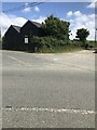
7
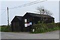
The renovated Black Garages near Treviskey
Recently repaired and repainted, the former wayside garage and petrol station's previous state can be seen in Image
Image: © Simon Mortimer
Taken: 13 Apr 2019
0.25 miles
8
Old Direction Sign - Signpost north of Trethennal Manor
Ball finial - three arms; Holman by the UC road, in parish of Veryan (Carrick District), Trethennal Manor, partly in the bank on the Southwest side of the crossroads North of Trethennal Manor. Opposite guide stone: CW_XVER2 Image
Surveyed
Milestone Society National ID: CW_SW9340B
Image: © I Thompson
Taken: 17 Sep 2010
0.25 miles