IMAGES TAKEN NEAR TO
Portloe, TRURO, TR2 5PL
Introduction
This page details the photographs taken nearby to TR2 5PL by members of the Geograph project.
The Geograph project started in 2005 with the aim of publishing, organising and preserving representative images for every square kilometre of Great Britain, Ireland and the Isle of Man.

There are currently over 7.5m images from over14,400 individuals and you can help contribute to the project by visiting https://www.geograph.org.uk
Image Map
Images are licensed for reuse under creativecommons.org/licenses/by-sa/2.0
Notes
- Clicking on the map will re-center to the selected point.
- The higher the marker number, the further away the image location is from the centre of the postcode.
Image Listing (3 Images Found)
Images are licensed for reuse under creativecommons.org/licenses/by-sa/2.0
Image
Details
Distance
1
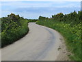
Hedge-lined road near Treviskey
Looking north-eastward.
Image: © Peter Wood
Taken: 5 May 2017
0.17 miles
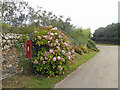
3
Old Direction Sign - Signpost by Treviskey, Veryan Parish
Ball finial - two missing arms; Holman casting by the UC road, in parish of Veryan (Carrick District), Treviskey, against bank, under trees, behind bus stop, South East side of junction. Possibly lost.
Surveyed
Milestone Society National ID: CW_SW9340A
Image: © Milestone Society
Taken: Unknown
0.23 miles