IMAGES TAKEN NEAR TO
Pendower, TRURO, TR2 5PE
Introduction
This page details the photographs taken nearby to Pendower, TR2 5PE by members of the Geograph project.
The Geograph project started in 2005 with the aim of publishing, organising and preserving representative images for every square kilometre of Great Britain, Ireland and the Isle of Man.

There are currently over 7.5m images from over14,400 individuals and you can help contribute to the project by visiting https://www.geograph.org.uk
Image Map
Images are licensed for reuse under creativecommons.org/licenses/by-sa/2.0
Notes
- Clicking on the map will re-center to the selected point.
- The higher the marker number, the further away the image location is from the centre of the postcode.
Image Listing (33 Images Found)
Images are licensed for reuse under creativecommons.org/licenses/by-sa/2.0
Image
Details
Distance
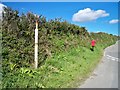
1
South West Coast Path sign at Pendower Beach
The upright has a small white label giving the OS grid reference
Image: © David Smith
Taken: 31 Jan 2013
0.13 miles
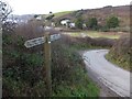
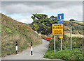
2
Direction Sign ? Signpost near Gwendra
Located on the northwest side of the T junction on Pendower Road northwest of Gwendra in Veryan parish. 3 arms and pyramid spear finial. For an older photograph before restoration in October 2011, https://www.geograph.org.uk/photo/6045624.
Milestone Society National ID: CW_SW9038
Image: © I Williams
Taken: 13 Jan 2021
0.15 miles
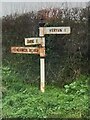
3
Old Direction Sign - Signpost near Gwendra
No finial - Two broken arms, one missing, no finial; Visick by the UC road, in parish of Veryan (Carrick District), near grass triangle at T-junction, on verge.
Surveyed
Milestone Society National ID: CW_SW9038
Image: © I Thompson
Taken: 17 Sep 2010
0.15 miles
4
Footbridge on South West Coast Path
A small bridge where the path crosses a stream which flows across Pendower Beach
Image: © David Smith
Taken: 31 Jan 2013
0.15 miles
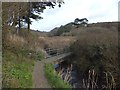
6
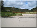
The valley at the back of Pendower Beach
The stream which powers Melinsey Mill Image flows down this valley and a footpath leads from the beach up the west side of the valley to the mill.
Image: © Rod Allday
Taken: 4 Sep 2009
0.16 miles
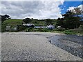
7
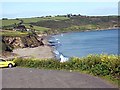
Pendower Beach
Looking east at sunset . In the distant background is Nare Head at SX915369
Image: © Nigel Mykura
Taken: 29 Sep 2018
0.16 miles
8
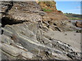
Rock strata, Pendower Beach
Interesting to see the different angles this rock strat is lying in the low cliffs behind Pendower Beach.
Image: © Philip Halling
Taken: 29 Sep 2010
0.18 miles
10
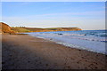
Shallikabooky Beach Hut from Pendower Beach
Looking back inland from Pendower Beach the building ahead is Shallikabooky Beach Hut selling ice creams, drinks and light meals. It is in a former hotel which is [as of 2023] partly boarded up.
Image: © Rob Farrow
Taken: 1 May 2023
0.18 miles