IMAGES TAKEN NEAR TO
Philleigh, TRURO, TR2 5NF
Introduction
This page details the photographs taken nearby to TR2 5NF by members of the Geograph project.
The Geograph project started in 2005 with the aim of publishing, organising and preserving representative images for every square kilometre of Great Britain, Ireland and the Isle of Man.

There are currently over 7.5m images from over14,400 individuals and you can help contribute to the project by visiting https://www.geograph.org.uk
Image Map
Images are licensed for reuse under creativecommons.org/licenses/by-sa/2.0
Notes
- Clicking on the map will re-center to the selected point.
- The higher the marker number, the further away the image location is from the centre of the postcode.
Image Listing (10 Images Found)
Images are licensed for reuse under creativecommons.org/licenses/by-sa/2.0
Image
Details
Distance
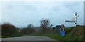
2
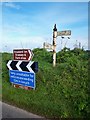
Old Direction Sign - Signpost by the B3289, south of Tolverne, Philleigh Parish
Pyramid spear finial - One arm broken off at sleeve; Cornwall CC iron spear by the B3289, in parish of Philleigh (Carrick District), South of Tolverne, on bank 2m from road edge.
Surveyed
Milestone Society National ID: CW_SW8539.
Image: © Milestone Society
Taken: Unknown
0.13 miles
3
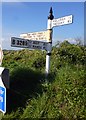
Direction Sign ? Signpost
Located on a bank 2 metres from the northeast side of the B3289 south of Tolverne in Philleigh parish. 3 arms and pyramid spear finial.
Milestone Society National ID: CW_SW8539
Image: © I Thompson
Taken: 18 Oct 2018
0.14 miles
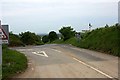
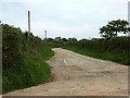
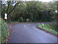
5
Road junction on road to King Harry Ferry
Image: © David Smith
Taken: 31 Jan 2013
0.15 miles
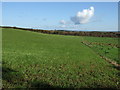
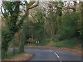
8
Sharp bend in the B3289
Towards St Just in Roseland.
Image: © JThomas
Taken: 5 Nov 2014
0.24 miles
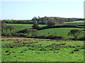
9
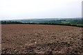
Cododden Wood
A sharp bend in the road to the King Harry Ferry
Image: © David Smith
Taken: 31 Jan 2013
0.24 miles