IMAGES TAKEN NEAR TO
Ruan High Lanes, TRURO, TR2 5LR
Introduction
This page details the photographs taken nearby to TR2 5LR by members of the Geograph project.
The Geograph project started in 2005 with the aim of publishing, organising and preserving representative images for every square kilometre of Great Britain, Ireland and the Isle of Man.

There are currently over 7.5m images from over14,400 individuals and you can help contribute to the project by visiting https://www.geograph.org.uk
Image Map
Images are licensed for reuse under creativecommons.org/licenses/by-sa/2.0
Notes
- Clicking on the map will re-center to the selected point.
- The higher the marker number, the further away the image location is from the centre of the postcode.
Image Listing (6 Images Found)
Images are licensed for reuse under creativecommons.org/licenses/by-sa/2.0
Image
Details
Distance
2
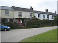
Terraced cottages in the hamlet of Treworthal
Image: © Rod Allday
Taken: 31 Jul 2009
0.03 miles
3
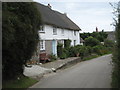
Thatched cottages at Treworthal
Some of several thatched houses in this attractive hamlet.
Image: © Rod Allday
Taken: 31 Jul 2009
0.04 miles
5
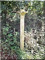
Old Direction Sign - Signpost east of Treworthal, Philleigh parish
No finial - Three arms and finial missing; broken disc; Bartle by the UC road, in parish of Philleigh (Carrick District), East of Treworthal, against hedge at T-junction.
Surveyed
Milestone Society National ID: CW_SW8838
Image: © Milestone Society
Taken: Unknown
0.17 miles
6
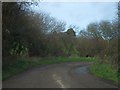
Stream beside road at Treluggan
A stream flows alongside the road, running from right to left, after a culvert round the corner. The stream rises very close to the coast (here it is just over 1km from the coast) but flows eastwards for nearly 10km to the Percuil River
Image: © David Smith
Taken: 31 Jan 2013
0.21 miles