IMAGES TAKEN NEAR TO
Ruan High Lanes, TRURO, TR2 5JS
Introduction
This page details the photographs taken nearby to TR2 5JS by members of the Geograph project.
The Geograph project started in 2005 with the aim of publishing, organising and preserving representative images for every square kilometre of Great Britain, Ireland and the Isle of Man.

There are currently over 7.5m images from over14,400 individuals and you can help contribute to the project by visiting https://www.geograph.org.uk
Image Map
Images are licensed for reuse under creativecommons.org/licenses/by-sa/2.0
Notes
- Clicking on the map will re-center to the selected point.
- The higher the marker number, the further away the image location is from the centre of the postcode.
Image Listing (5 Images Found)
Images are licensed for reuse under creativecommons.org/licenses/by-sa/2.0
Image
Details
Distance
2
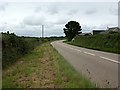
A3078 junction for Ruan Lanihorne
The size of the sign belies the narrowness of the road on the right. As is common in the area, the field gate on the right has a granite post
Image: © David Smith
Taken: 31 Jan 2013
0.20 miles
4
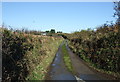
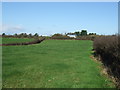
Lane towards Tregongon
Heading north from the A3078.
Image: © JThomas
Taken: 5 Nov 2014
0.23 miles