IMAGES TAKEN NEAR TO
Ruan High Lanes, TRURO, TR2 5JR
Introduction
This page details the photographs taken nearby to TR2 5JR by members of the Geograph project.
The Geograph project started in 2005 with the aim of publishing, organising and preserving representative images for every square kilometre of Great Britain, Ireland and the Isle of Man.

There are currently over 7.5m images from over14,400 individuals and you can help contribute to the project by visiting https://www.geograph.org.uk
Image Map
Images are licensed for reuse under creativecommons.org/licenses/by-sa/2.0
Notes
- Clicking on the map will re-center to the selected point.
- The higher the marker number, the further away the image location is from the centre of the postcode.
Image Listing (9 Images Found)
Images are licensed for reuse under creativecommons.org/licenses/by-sa/2.0
Image
Details
Distance
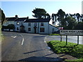
1
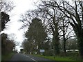
An array of roadside signs
The nearer signs advertise a plant centre; beyond that is a hotel. Mixed with these are two signs indicating a 40mph limit
Image: © David Smith
Taken: 31 Jan 2013
0.06 miles
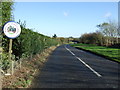
2
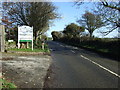
A3078 towards Tregony
Heading north east by Roseland Plant Centre.
Image: © JThomas
Taken: 5 Nov 2014
0.07 miles
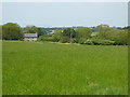
8
Farmland, Ruanlanihorne
A cereal crop and rolling countryside viewed from the road north of Ruan High Lanes.
Image: © Andrew Smith
Taken: 10 Feb 2022
0.24 miles
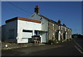
9
Ruan High Lanes
Small settlement on the A3078.
Image: © JThomas
Taken: 5 Nov 2014
0.25 miles