IMAGES TAKEN NEAR TO
The Bowling Green, TRURO, TR2 5JN
Introduction
This page details the photographs taken nearby to The Bowling Green, TR2 5JN by members of the Geograph project.
The Geograph project started in 2005 with the aim of publishing, organising and preserving representative images for every square kilometre of Great Britain, Ireland and the Isle of Man.

There are currently over 7.5m images from over14,400 individuals and you can help contribute to the project by visiting https://www.geograph.org.uk
Image Map
Images are licensed for reuse under creativecommons.org/licenses/by-sa/2.0
Notes
- Clicking on the map will re-center to the selected point.
- The higher the marker number, the further away the image location is from the centre of the postcode.
Image Listing (20 Images Found)
Images are licensed for reuse under creativecommons.org/licenses/by-sa/2.0
Image
Details
Distance
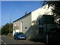
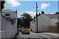
2
New houses beside the B3289 in St Just in Roseland
Image: © Rod Allday
Taken: 12 Jun 2016
0.06 miles
3
The A 3078
Attractive stone cottages in St Just.
Image: © Robert Ashby
Taken: 19 Aug 2014
0.06 miles
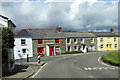
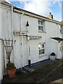
4
Cottages, St Just-in-Roseland
The B3289 forks off to the left in the centre of the village beside cottages brightened by their paintwork and a sunny interval on a showery day.
Image: © Andrew Smith
Taken: 9 Jan 2023
0.07 miles
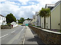
5
In St Just
The B3289 going through St Just in Roseland.
Image: © Robert Ashby
Taken: 19 Aug 2014
0.07 miles
6
Old Direction Sign - Signpost by the B3289, St Just in Roseland parish
Raised finial - G type; by the B3289, in parish of St Just in Roseland (Carrick District), in front of Clome Cottage, against cottage wall.
Cornwall & Scilly HER.
HER Number: MCO56024 https://www.heritagegateway.org.uk/Gateway/Results_Single.aspx?uid=MCO56024&resourceID=1020
Surveyed
Milestone Society National ID: CW_SW8535B
Image: © Milestone Society
Taken: Unknown
0.07 miles
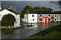
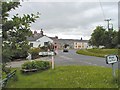
7
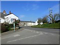
Road junction at St Just in Roseland
Image: © Ruth Sharville
Taken: 21 Mar 2012
0.08 miles
8
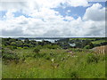
Highly desirable building plot at St Just in Roseland
The last remaining plot on this small development site, with far reaching views across Carrick Roads.
Image: © Rod Allday
Taken: 12 Jun 2016
0.09 miles
9
St Just in Roseland
Looking N along the main street
Image: © Chris J Dixon
Taken: 21 Jun 2005
0.09 miles
10
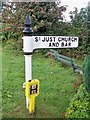
Old Direction Sign - Signpost by the A3078, St Just in Roseland
Pyramid finial - 3 arms; plain pyramid by the A3078, in parish of St Just in Roseland (Carrick District), St Just church turning, on grass beside flower filled boat, 4m from road.
Cornwall & Scilly HER.
HER Number: MCO56024 https://www.heritagegateway.org.uk/Gateway/Results_Single.aspx?uid=MCO56024&resourceID=1020
Surveyed
Milestone Society National ID: CW_SW8535
Image: © Milestone Society
Taken: Unknown
0.09 miles