IMAGES TAKEN NEAR TO
Springfield, TRURO, TR2 5HS
Introduction
This page details the photographs taken nearby to Springfield, TR2 5HS by members of the Geograph project.
The Geograph project started in 2005 with the aim of publishing, organising and preserving representative images for every square kilometre of Great Britain, Ireland and the Isle of Man.

There are currently over 7.5m images from over14,400 individuals and you can help contribute to the project by visiting https://www.geograph.org.uk
Image Map
Images are licensed for reuse under creativecommons.org/licenses/by-sa/2.0
Notes
- Clicking on the map will re-center to the selected point.
- The higher the marker number, the further away the image location is from the centre of the postcode.
Image Listing (65 Images Found)
Images are licensed for reuse under creativecommons.org/licenses/by-sa/2.0
Image
Details
Distance
2
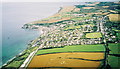
Aerial view from Paramotor of Portscatho
Roseland Peninsula
Image: © Dave Price
Taken: 11 Aug 2005
0.03 miles
3
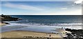
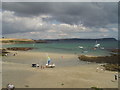
Porthcurnick Beach, Cornwall
This photograph was taken on Christmas Day.
Image: © Ian Hawfinch
Taken: 25 Dec 2019
0.07 miles
4

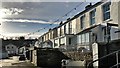
Portscatho, Cornwall
This photo was taken on Christmas Day. The village was very quiet.
Image: © Ian Hawfinch
Taken: 25 Dec 2019
0.07 miles
5
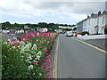
North Parade, Portscatho
This photograph was taken on Christmas Day.
Image: © Ian Hawfinch
Taken: 25 Dec 2019
0.08 miles
6
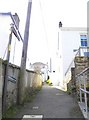
Hetherington's Ope
This is the Public Footpath in Portscatho, signposted Hetherington's Ope.
Image: © ROWLAND TURNER
Taken: 7 Apr 2010
0.10 miles
8
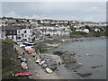
Portscatho - seafront
Looking along the curving seafront of the village of Portscatho from the coastal street called "The Lugger". Lugger usually refers to a type of boat, but in this part of Cornwall it seems to be a common name for a coastal road or lane.
Portscatho is situated on the eastern coast of the Roseland peninsula about 7miles (11km) south of Truro. Its name comes from the Cornish words for harbour or cove (porth https://www.cornishdictionary.org.uk/?locale=en#harbour ) and boats (skathow https://www.cornishdictionary.org.uk/?locale=en#boat ).
Image: © Rob Farrow
Taken: 1 May 2023
0.11 miles
10
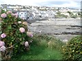
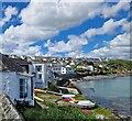
Beach at Portscatho
The village has a small beach flanked by rocks which is completely covered at high tide.
Image: © Trevor Rickard
Taken: 10 Sep 2007
0.11 miles