IMAGES TAKEN NEAR TO
The Quay, TRURO, TR2 5HF
Introduction
This page details the photographs taken nearby to The Quay, TR2 5HF by members of the Geograph project.
The Geograph project started in 2005 with the aim of publishing, organising and preserving representative images for every square kilometre of Great Britain, Ireland and the Isle of Man.

There are currently over 7.5m images from over14,400 individuals and you can help contribute to the project by visiting https://www.geograph.org.uk
Image Map
Images are licensed for reuse under creativecommons.org/licenses/by-sa/2.0
Notes
- Clicking on the map will re-center to the selected point.
- The higher the marker number, the further away the image location is from the centre of the postcode.
Image Listing (66 Images Found)
Images are licensed for reuse under creativecommons.org/licenses/by-sa/2.0
Image
Details
Distance

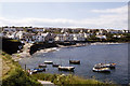
5
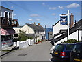
Plume of Feathers
Plume of Feathers pub in Portscatho.
Image: © Philip Halling
Taken: 29 Sep 2010
0.02 miles
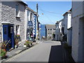
7
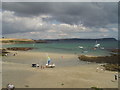
Next stop the sea! Portscatho
I was depending on a friend who lives locally to navigate me, and he forgot to tell me to turn left higher up the village... so I was heading straight for the water. I was lucky it was quiet and I could reverse and turn round...
Image: © Ruth Sharville
Taken: 21 Mar 2012
0.03 miles
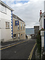
9
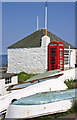
Boatmens Shelter off The Lugger, Portscatho
Grade II Listed early 19th century shelter.
Image: © Jo and Steve Turner
Taken: 9 Jun 2005
0.03 miles
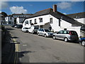
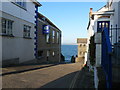
10
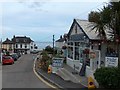
The Boathouse Cafe in the centre of Porscatho
Image: © Neil Theasby
Taken: 11 Jul 2010
0.03 miles