IMAGES TAKEN NEAR TO
St. Anthony, TRURO, TR2 5EZ
Introduction
This page details the photographs taken nearby to St. Anthony, TR2 5EZ by members of the Geograph project.
The Geograph project started in 2005 with the aim of publishing, organising and preserving representative images for every square kilometre of Great Britain, Ireland and the Isle of Man.

There are currently over 7.5m images from over14,400 individuals and you can help contribute to the project by visiting https://www.geograph.org.uk
Image Map
Images are licensed for reuse under creativecommons.org/licenses/by-sa/2.0
Notes
- Clicking on the map will re-center to the selected point.
- The higher the marker number, the further away the image location is from the centre of the postcode.
Image Listing (27 Images Found)
Images are licensed for reuse under creativecommons.org/licenses/by-sa/2.0
Image
Details
Distance
2

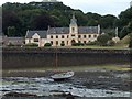
Place House
Viewed from the South West Coast Path.
Image: © Chris Thomas-Atkin
Taken: 18 Sep 2019
0.01 miles
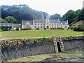
3
Place House
Now a private house, Place was originally a monastery. Until 1862 the area of lawn was a tidal mill pool but the then owner, Sir Samuel Spry, having rebuilt the house, demolished the mill and built the new causeway seen in the foreground here, filling in the pool to form the lawn. This was one of three tidal mills in the immediate area - an informative article is here: http://www.rootsweb.ancestry.com/~enggerop/Mills_Gerrans.htm
Image: © Rod Allday
Taken: 31 Jul 2009
0.01 miles
4
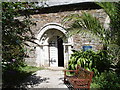
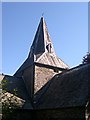
St Anthony-in-Roseland
The parish church of St Anthony was built in 1150 and is designated as a Grade II* listed building. It is now in the care of the Churches Conservation Trust. The church still has its original mediaeval cruciform plan, more or less as it was built in the 12th and 13th centuries.
Image: © Richard Rogerson
Taken: 3 Jul 2015
0.02 miles
5
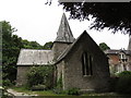
Church of St Anthony
The parish church of St Anthony, which was built in 1150 and is a Grade II* (star) listed building. See https://historicengland.org.uk/listing/the-list/list-entry/1141049
Image: © Chris Thomas-Atkin
Taken: 18 Sep 2019
0.02 miles
6
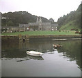
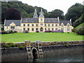
Place House
View from the coast path at high tide looking south across the extensive lawns in front of the house. The privately owned Place House was built in 1840 and occupies the site of an Augustinian priory, which was founded in 1124 by Warlewast, the Bishop of Exeter.
Image: © Trevor Rickard
Taken: Unknown
0.02 miles
7
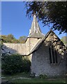
St Anthony Church Spire
Although this church is tucked away behind Place House, viewers of the front of the house will see this spire poking out above the roof.
Image: © Tony Atkin
Taken: 15 Aug 2005
0.03 miles
9
Place House, St Anthony
The retaining wall follows the line of an earlier tide mill dam, the area of the old mill pond now being lawn.
Image: © Chris J Dixon
Taken: 26 Jun 2005
0.03 miles