IMAGES TAKEN NEAR TO
St. Anthony, TRURO, TR2 5EY
Introduction
This page details the photographs taken nearby to St. Anthony, TR2 5EY by members of the Geograph project.
The Geograph project started in 2005 with the aim of publishing, organising and preserving representative images for every square kilometre of Great Britain, Ireland and the Isle of Man.

There are currently over 7.5m images from over14,400 individuals and you can help contribute to the project by visiting https://www.geograph.org.uk
Image Map
Images are licensed for reuse under creativecommons.org/licenses/by-sa/2.0
Notes
- Clicking on the map will re-center to the selected point.
- The higher the marker number, the further away the image location is from the centre of the postcode.
Image Listing (27 Images Found)
Images are licensed for reuse under creativecommons.org/licenses/by-sa/2.0
Image
Details
Distance
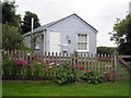
2
The old schoolhouse
The old Victorian school in the hamlet of Bohortha, which is now a private residence.
Image: © ROWLAND TURNER
Taken: 3 Apr 2009
0.04 miles
3
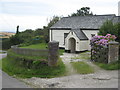
The Old Schoolhouse in Bohortha
Now a private dwelling.
Image: © Rod Allday
Taken: 31 Jul 2009
0.04 miles
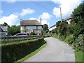
5
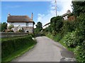
Bohortha
As seen from the coastal road from St Anthony head on the way back inland.
Image: © roger geach
Taken: 19 Jun 2012
0.06 miles
6
'The Boathouse'
A pretty little cabin in the hamlet of Bohortha.
Image: © Rod Allday
Taken: 31 Jul 2009
0.06 miles
7
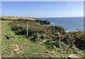
Path junction near Bohortha
The hamlet of Bohortha is inland from Porthbeor Beach.
Image: © Chris Thomas-Atkin
Taken: 18 Sep 2019
0.14 miles
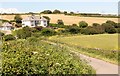
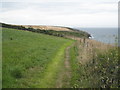
8
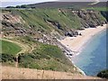
The South West Coastal Path west of Porthbeor Beach
Image: © Rod Allday
Taken: 31 Jul 2009
0.17 miles
9
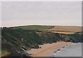
Porthbeor Beach on the Roseland Peninsula
Image: © Peter Robinson
Taken: Unknown
0.20 miles