IMAGES TAKEN NEAR TO
Portscatho, TRURO, TR2 5EU
Introduction
This page details the photographs taken nearby to TR2 5EU by members of the Geograph project.
The Geograph project started in 2005 with the aim of publishing, organising and preserving representative images for every square kilometre of Great Britain, Ireland and the Isle of Man.

There are currently over 7.5m images from over14,400 individuals and you can help contribute to the project by visiting https://www.geograph.org.uk
Image Map
Images are licensed for reuse under creativecommons.org/licenses/by-sa/2.0
Notes
- Clicking on the map will re-center to the selected point.
- The higher the marker number, the further away the image location is from the centre of the postcode.
Image Listing (8 Images Found)
Images are licensed for reuse under creativecommons.org/licenses/by-sa/2.0
Image
Details
Distance
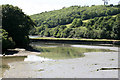
2
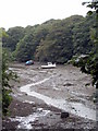
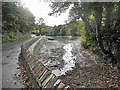
The head of the creek at Froe
Seen at low tide.
Image: © Rod Allday
Taken: 31 Jul 2009
0.14 miles
3
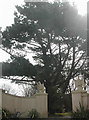
'Guardian Eagles'
The impressive gateway to Trewince manor.
Image: © ROWLAND TURNER
Taken: 3 Apr 2009
0.15 miles
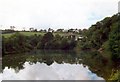
5
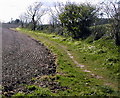
Rosteague to Froe
This is the public bridleway from Rosteague Manor to Froe.
Image: © ROWLAND TURNER
Taken: 3 Apr 2009
0.21 miles
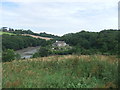
6
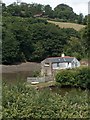
View of the Tide Mill and Porth Creek, Froe
Image: © Neil Theasby
Taken: 11 Jul 2010
0.21 miles