IMAGES TAKEN NEAR TO
Portscatho, TRURO, TR2 5ES
Introduction
This page details the photographs taken nearby to TR2 5ES by members of the Geograph project.
The Geograph project started in 2005 with the aim of publishing, organising and preserving representative images for every square kilometre of Great Britain, Ireland and the Isle of Man.

There are currently over 7.5m images from over14,400 individuals and you can help contribute to the project by visiting https://www.geograph.org.uk
Image Map
Images are licensed for reuse under creativecommons.org/licenses/by-sa/2.0
Notes
- Clicking on the map will re-center to the selected point.
- The higher the marker number, the further away the image location is from the centre of the postcode.
Image Listing (2 Images Found)
Images are licensed for reuse under creativecommons.org/licenses/by-sa/2.0
Image
Details
Distance
1
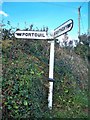
Old Direction Sign - Signpost, east of Tregassick
Ball finial - One bolted repair; one arm missing; Holman by the UC road, in parish of Gerrans (Carrick District), Tregassick turn, Percuil Road, on verge 1.5m from road.
Grade II listed. List Entry Number: 1391131
https://historicengland.org.uk/listing/the-list/list-entry/1391131
Surveyed
Milestone Society National ID: CW_SW8734.
Image: © Milestone Society
Taken: Unknown
0.17 miles