IMAGES TAKEN NEAR TO
Bohella Road, TRURO, TR2 5DL
Introduction
This page details the photographs taken nearby to Bohella Road, TR2 5DL by members of the Geograph project.
The Geograph project started in 2005 with the aim of publishing, organising and preserving representative images for every square kilometre of Great Britain, Ireland and the Isle of Man.

There are currently over 7.5m images from over14,400 individuals and you can help contribute to the project by visiting https://www.geograph.org.uk
Image Map
Images are licensed for reuse under creativecommons.org/licenses/by-sa/2.0
Notes
- Clicking on the map will re-center to the selected point.
- The higher the marker number, the further away the image location is from the centre of the postcode.
Image Listing (120 Images Found)
Images are licensed for reuse under creativecommons.org/licenses/by-sa/2.0
Image
Details
Distance
1
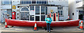
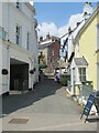
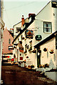
Pomery's Garage, Kings Road, St Mawes
St. Just and St. Mawes Heritage Group are working to renovate this building as a permanent Heritage Centre. It had various uses from a pilchard shed to a WW2 reading room to an artist’s studio to a garage to a gig club. The gig is an active racing boat based on pilot boats of the 17th century. They dispatched from shore to lead or rescue ships through the rocky Cornish shores to safe harbour, often racing to collect their fees. The boats are 32 feet long, 5 feet wide and propelled by six oarsmen. On the wall is a village sign. Although the 1903 legislation required local authorities to erect some traffic management signage, the AA started erecting village signs in 1906 and had erected more than 30,000 when the local authorities took responsibility for all signage in 1939. Most were removed during the war when a Nazi invasion seemed likely so by 1945 only about 600 remained and today only about 65 are still in situ. This looks to be an original post 1923 sign.
Image: © Jo and Steve Turner
Taken: 2 Jul 2019
0.01 miles
2
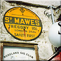
Old AA Sign on Kings Road, St Mawes
Old AA Sign set on the wall of Pomeroys Garage, the Roseland Gig Club on the northwest side of the A3078 Kings Road, St Mawes, 3 miles east of Falmouth. St Just in Roseland parish.
This is the Circular, village name on black band, no Motor Union symbol or name type, dating from 1923, showing distances Tregony 10½ London 263¼. The sign was removed from the wall at some time between October 2018 and October 2022.
There were five series of AA signs, mostly dating from 1923 and made by Francis & Co / Franco in Deptford, London. The village name and distance to London or Dublin were normally displayed.
See also https://www.geograph.org.uk/photo/3467287 and https://www.flickr.com/photos/keith-v/50787900342.
Milestone Society National ID: CW-STMAW
Image: © Milestone Society
Taken: Unknown
0.01 miles
3
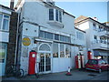
Old filling station in St. Mawes
Non-operational I assume but nice to see.
Image: © Jeremy Bolwell
Taken: 18 May 2013
0.01 miles
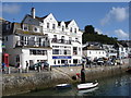
6
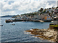
St Mawes Harbour & Quay
From Tredenham Road.
Image: © David Dixon
Taken: 10 Aug 2004
0.03 miles
7
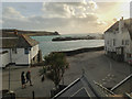
Waterfront & pier at St. Mawes
This view, taken from a bedroom at the Rising Sun Inn Image, shows how the narrow A3078 main road winds through the village following the coastline and with the working pier in the background, from where the ferry plies to/from Falmouth,
Image: © Mike Dodman
Taken: 26 Feb 2014
0.03 miles
8
By The Square, St Mawes
On the left is a slipway. On the right, Kings Road runs along the waterfront towards the Ship and Castle.
Image: © Derek Harper
Taken: 19 Jul 2016
0.03 miles
10
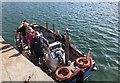
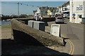
Place Ferry
The ferry from Place just docked.
Image: © Chris Thomas-Atkin
Taken: 18 Sep 2019
0.04 miles