IMAGES TAKEN NEAR TO
The Square, TRURO, TR2 5DJ
Introduction
This page details the photographs taken nearby to The Square, TR2 5DJ by members of the Geograph project.
The Geograph project started in 2005 with the aim of publishing, organising and preserving representative images for every square kilometre of Great Britain, Ireland and the Isle of Man.

There are currently over 7.5m images from over14,400 individuals and you can help contribute to the project by visiting https://www.geograph.org.uk
Image Map
Images are licensed for reuse under creativecommons.org/licenses/by-sa/2.0
Notes
- Clicking on the map will re-center to the selected point.
- The higher the marker number, the further away the image location is from the centre of the postcode.
Image Listing (101 Images Found)
Images are licensed for reuse under creativecommons.org/licenses/by-sa/2.0
Image
Details
Distance
1
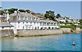
St Mawes: Terrace of The Idle Rocks Hotel
Image: © Mr Eugene Birchall
Taken: 21 Jul 2014
0.03 miles
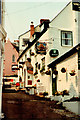
2
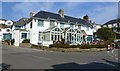
The Rising Sun public house, St Mawes
It was good to eat "al fresco" on this beautiful March day.
Image: © Ruth Sharville
Taken: 21 Mar 2012
0.03 miles
3
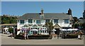
Rising Sun, St Mawes
A slightly different angle on Image, which sits in the middle of The Square.
Image: © Derek Harper
Taken: 19 Jul 2016
0.03 miles
5
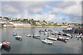
St Mawes from the Harbour
General view of St Mawes including the Idle Rocks Hotel, part of Summers Beach and one of the Falmouth Ferries.
Image: © David Wickham
Taken: 9 Sep 2019
0.03 miles
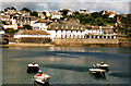
8
Waterfront & pier at St. Mawes
This view, taken from a bedroom at the Rising Sun Inn Image, shows how the narrow A3078 main road winds through the village following the coastline and with the working pier in the background, from where the ferry plies to/from Falmouth,
Image: © Mike Dodman
Taken: 26 Feb 2014
0.04 miles
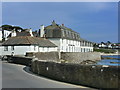
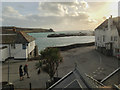
9
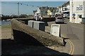
By The Square, St Mawes
On the left is a slipway. On the right, Kings Road runs along the waterfront towards the Ship and Castle.
Image: © Derek Harper
Taken: 19 Jul 2016
0.04 miles
10
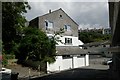
St Mawes old fire station
St Mawes old fire station, Bohella Road, St Mawes, Cornwall, now converted into a shop.
Image: © Kevin Hale
Taken: 8 Jul 2007
0.05 miles