IMAGES TAKEN NEAR TO
Sea View Crescent, TRURO, TR2 5BW
Introduction
This page details the photographs taken nearby to Sea View Crescent, TR2 5BW by members of the Geograph project.
The Geograph project started in 2005 with the aim of publishing, organising and preserving representative images for every square kilometre of Great Britain, Ireland and the Isle of Man.

There are currently over 7.5m images from over14,400 individuals and you can help contribute to the project by visiting https://www.geograph.org.uk
Image Map
Images are licensed for reuse under creativecommons.org/licenses/by-sa/2.0
Notes
- Clicking on the map will re-center to the selected point.
- The higher the marker number, the further away the image location is from the centre of the postcode.
Image Listing (128 Images Found)
Images are licensed for reuse under creativecommons.org/licenses/by-sa/2.0
Image
Details
Distance
4
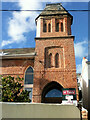
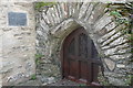
Catholic Church of Our Lady Star of the Sea and St Anthony
Image: © Paul Barnett
Taken: Unknown
0.09 miles
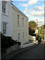
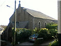
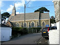
5
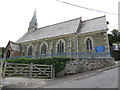
St. Mawes parish church
The church was built in 1882.
Image: © Richard Rogerson
Taken: 3 Jul 2015
0.09 miles
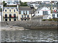
6
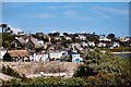
St Mawes
Looking towards the town from Lower Castle Road
Image: © David Dixon
Taken: 10 Aug 2004
0.10 miles
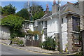
8
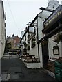
The Victory Inn, St Mawes
Tucked away on Victory Hill just off of the harbour you can find the Victory Inn.
Image: © Steve Barnes
Taken: 5 Sep 2010
0.10 miles