IMAGES TAKEN NEAR TO
Buckeys Lane, TRURO, TR2 5AP
Introduction
This page details the photographs taken nearby to Buckeys Lane, TR2 5AP by members of the Geograph project.
The Geograph project started in 2005 with the aim of publishing, organising and preserving representative images for every square kilometre of Great Britain, Ireland and the Isle of Man.

There are currently over 7.5m images from over14,400 individuals and you can help contribute to the project by visiting https://www.geograph.org.uk
Image Map
Images are licensed for reuse under creativecommons.org/licenses/by-sa/2.0
Notes
- Clicking on the map will re-center to the selected point.
- The higher the marker number, the further away the image location is from the centre of the postcode.
Image Listing (22 Images Found)
Images are licensed for reuse under creativecommons.org/licenses/by-sa/2.0
Image
Details
Distance
2
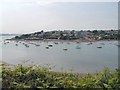
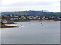
St Mawes
Seen from near North-hill Point
Image: © Chris J Dixon
Taken: 26 Jun 2005
0.08 miles
6
Summers Beach from Tredenham Road, St Mawes, Cornwall
Image: © Gary Rogers
Taken: 26 May 2016
0.10 miles
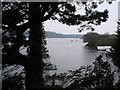
7
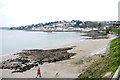
Beach at Polvarth Point
The beach here is a mixture of sand and large slabs of exposed rock. In the background is St Mawes.
Image: © Nigel Mykura
Taken: 27 Feb 2016
0.12 miles
9
St Mawes
Looking across the Fal estuary towards St Mawes; viewed from Image
Image: © David Dixon
Taken: 27 Jul 2010
0.14 miles
10
View down Percuil River in the St Mawes direction
The St Mawes boatyard is just around the next headland
Image: © Tom Jolliffe
Taken: 25 Mar 2007
0.15 miles