IMAGES TAKEN NEAR TO
St. Mawes, TRURO, TR2 5AE
Introduction
This page details the photographs taken nearby to TR2 5AE by members of the Geograph project.
The Geograph project started in 2005 with the aim of publishing, organising and preserving representative images for every square kilometre of Great Britain, Ireland and the Isle of Man.

There are currently over 7.5m images from over14,400 individuals and you can help contribute to the project by visiting https://www.geograph.org.uk
Image Map
Images are licensed for reuse under creativecommons.org/licenses/by-sa/2.0
Notes
- Clicking on the map will re-center to the selected point.
- The higher the marker number, the further away the image location is from the centre of the postcode.
Image Listing (11 Images Found)
Images are licensed for reuse under creativecommons.org/licenses/by-sa/2.0
Image
Details
Distance
1
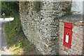
Postbox, Halwartha
Elizabeth II postbox TR2 219 is on the wall of a cottage by the A3078. On the left is the junction where the main road divides.
Image: © Derek Harper
Taken: 19 Jul 2016
0.07 miles
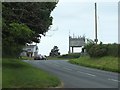
2
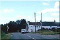
The A 3078
Heading south through Halwartha.
Image: © Robert Ashby
Taken: 19 Aug 2014
0.09 miles
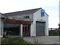
3

Disused Garage on the A3078 at Halwartha
Looks like it was once an Austin Morris Service Centre
Image: © Gary Rogers
Taken: 26 May 2016
0.10 miles
4
Garage at Halwartha
Very similar to Gary's Image The Austin /Morris sign still remains. I love the "keep off the grass" sign!
Image: © Derek Harper
Taken: 19 Jul 2016
0.10 miles
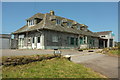
5
Disused Austin Morris Garage on the A3078 outside St Mawes
Image: © Gary Rogers
Taken: 26 May 2016
0.10 miles
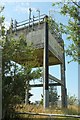
7
Disused Garage and Water Tower on the A3078 outside St Mawes
Image: © Gary Rogers
Taken: 26 May 2016
0.14 miles
8
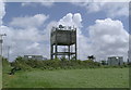
The water tower at Halwartha
This prominent landmark on high ground is clearly an ideal location for cellphone transmitters.
Image: © Rod Allday
Taken: 12 Jun 2016
0.15 miles
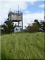
9
Water tower at Halwartha
Also shown at http://www.geograph.org.uk/search.php?i=67750771 , and seen from a gateway on the A3078. A very prominent and distinctive feature, but I suppose not that pretty.
Image: © Derek Harper
Taken: 19 Jul 2016
0.15 miles
10
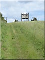
Footpath leading to Halwartha
Looking towards Image
Image: © Rod Allday
Taken: 12 Jun 2016
0.17 miles