IMAGES TAKEN NEAR TO
Tresillian, TRURO, TR2 4TF
Introduction
This page details the photographs taken nearby to TR2 4TF by members of the Geograph project.
The Geograph project started in 2005 with the aim of publishing, organising and preserving representative images for every square kilometre of Great Britain, Ireland and the Isle of Man.

There are currently over 7.5m images from over14,400 individuals and you can help contribute to the project by visiting https://www.geograph.org.uk
Image Map
Images are licensed for reuse under creativecommons.org/licenses/by-sa/2.0
Notes
- Clicking on the map will re-center to the selected point.
- The higher the marker number, the further away the image location is from the centre of the postcode.
Image Listing (14 Images Found)
Images are licensed for reuse under creativecommons.org/licenses/by-sa/2.0
Image
Details
Distance


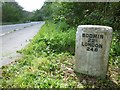
7
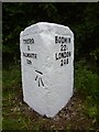
Old Milestone by the A390, Pencalenick Wood
Metal plates attached to stone post by the A390, in parish of St Clement (Carrick District), Woodcock Corner, Tresillian, below steep embankment, by the road, on South side of road. Truro iron plate, erected by the Truro turnpike trust in the 19th century.
Inscription reads:-
TRURO / 2 / FALMOUTH / 12½ : : BODMIN / 22¼ / LONDON / 248
Carved benchmark on front face.
Grade II Listed. List Entry Number: 1396474
Milestone Society National ID: CW_BMTO22.
Image: © Paul Barnett
Taken: 20 Jan 2023
0.13 miles
8
Old Milestone by the A390, Woodcock Corner
Metal plate attached to stone post by the A390, in parish of ST CLEMENT (CARRICK District), Woodcock Corner, Tresillian, below steep embankment, by the road, on South side of road. Truro iron plate, erected by the Truro turnpike trust in the 19th century.
Inscription reads:-
: TRURO / 2 / FALMOUTH / 12½ : : BODMIN / 22¼ / LONDON / 248 :
Carved benchmark on left face.
Grade II listed.
List Entry Number: 1396474 https://historicengland.org.uk/listing/the-list/list-entry/1396474
Milestone Society National ID: CW_BMTO22.
Image: © Rosy Hanns
Taken: 5 May 2019
0.16 miles
9
Old Milestone by the A390, Pencalenick Wood
Metal plates attached to stone post by the A390, in parish of ST CLEMENT (CARRICK District), Woodcock Corner, Tresillian, below steep embankment, by the road, on South side of road. Truro iron plate, erected by the Truro turnpike trust in the 19th century.
Inscription reads:-
: TRURO / 2 / FALMOUTH / 12½ : : BODMIN / 22¼ / LONDON / 248 :
Carved benchmark on front face.
Grade II Listed. List Entry Number: 1396474
https://historicengland.org.uk/listing/the-list/list-entry/1396474
Milestone Society National ID: CW_BMTO22.
Image: © Ian Thompson
Taken: 1 Jan 1998
0.17 miles
10
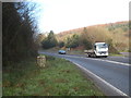
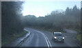
Milestone beside the A390 at Tregoninny
The milestone, which used to be on the main route into Truro, via the River Fal bridge at Grampound, reads 'TRURO 2, FALMOUTH 12'. It must have been relocated slightly in the 1980s when the road was improved. The route of the old road can be seen in the lay-by to the right of the photo.
Image: © Rod Allday
Taken: 7 Feb 2012
0.17 miles