IMAGES TAKEN NEAR TO
Grampound, TRURO, TR2 4SW
Introduction
This page details the photographs taken nearby to TR2 4SW by members of the Geograph project.
The Geograph project started in 2005 with the aim of publishing, organising and preserving representative images for every square kilometre of Great Britain, Ireland and the Isle of Man.

There are currently over 7.5m images from over14,400 individuals and you can help contribute to the project by visiting https://www.geograph.org.uk
Image Map
Images are licensed for reuse under creativecommons.org/licenses/by-sa/2.0
Notes
- Clicking on the map will re-center to the selected point.
- The higher the marker number, the further away the image location is from the centre of the postcode.
Image Listing (6 Images Found)
Images are licensed for reuse under creativecommons.org/licenses/by-sa/2.0
Image
Details
Distance
1
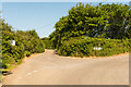
Unsuitable for vehicles!!
A very narrow (and unclassified) lane leading off the road past Treswallen towards the village of Creed. The white sign on the left says "Unsuitable for through traffic. Do not follow satnav on this road"
Image: © Mike Lyne
Taken: 25 May 2020
0.15 miles
2
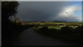
Shower clouds as seen from Treswallen near Grampound
Image: © Colin Park
Taken: 6 Nov 2016
0.15 miles
3
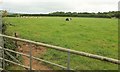
Cattle near Treswallen
Image: © Derek Harper
Taken: 20 Jul 2016
0.17 miles
5
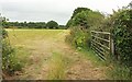
Field near Treswallen
From the same spot as Image] and adjacent to that field.
Image: © Derek Harper
Taken: 20 Jul 2016
0.21 miles
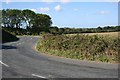
6
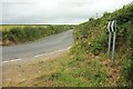
Lane to Grampound
Nor directly, of course. in fact you could easily go the other way, shown in Image and which was taken from the same spot.
Image: © Derek Harper
Taken: 20 Jul 2016
0.24 miles