IMAGES TAKEN NEAR TO
Grampound, TRURO, TR2 4SN
Introduction
This page details the photographs taken nearby to TR2 4SN by members of the Geograph project.
The Geograph project started in 2005 with the aim of publishing, organising and preserving representative images for every square kilometre of Great Britain, Ireland and the Isle of Man.

There are currently over 7.5m images from over14,400 individuals and you can help contribute to the project by visiting https://www.geograph.org.uk
Image Map
Images are licensed for reuse under creativecommons.org/licenses/by-sa/2.0
Notes
- Clicking on the map will re-center to the selected point.
- The higher the marker number, the further away the image location is from the centre of the postcode.
Image Listing (3 Images Found)
Images are licensed for reuse under creativecommons.org/licenses/by-sa/2.0
Image
Details
Distance
1
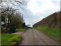
Tregonjohn, on the road from Fair Cross to Creed
This was taken at Tregonjohn on the back-road between Fair Cross and Creed, note the subtle Topiary on the LH side of the road
Image: © Mike Lyne
Taken: 22 Jan 2012
0.18 miles
2
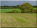
Farmland, Creed
Cut silage and pasture beside the road at Tregonjohn.
Image: © Andrew Smith
Taken: 8 May 2019
0.21 miles
3
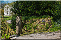
Entrance to Creed House
Driveway entrance to Creed House in the village of Creed with the house just visible in the background.
Image: © Mike Lyne
Taken: 14 Apr 2020
0.22 miles