IMAGES TAKEN NEAR TO
Creed Lane, TRURO, TR2 4SD
Introduction
This page details the photographs taken nearby to Creed Lane, TR2 4SD by members of the Geograph project.
The Geograph project started in 2005 with the aim of publishing, organising and preserving representative images for every square kilometre of Great Britain, Ireland and the Isle of Man.

There are currently over 7.5m images from over14,400 individuals and you can help contribute to the project by visiting https://www.geograph.org.uk
Image Map
Images are licensed for reuse under creativecommons.org/licenses/by-sa/2.0
Notes
- Clicking on the map will re-center to the selected point.
- The higher the marker number, the further away the image location is from the centre of the postcode.
Image Listing (42 Images Found)
Images are licensed for reuse under creativecommons.org/licenses/by-sa/2.0
Image
Details
Distance
1
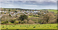
South Grampound from the west on Barteliver Hill
The southern side of Grampound village (off the A390 - Truro to St Austell Road) taken from the unclassified road towards Barteliver Farm.
Image: © Mike Lyne
Taken: 6 Apr 2020
0.01 miles
2
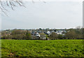
South East view of Grampound
A photo taken in Creed Lane predominantly showing some of the new houses built on the site of the last Tannery to be operating in Grampound (it closed in 2002).
Image: © Mike Lyne
Taken: 12 Apr 2020
0.04 miles
3
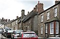
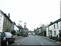
Grampound Village
Looking up the main street from by the church. The only time the villagers get a break from this traffic is when they stop it for the annual carnival procession.
Image: © Tony Atkin
Taken: 8 Jul 2006
0.04 miles
5
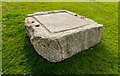
Granite Leather Press Base?
This looks like a granite base for a press of some kind and used to compress some material to force out a liquid. The four (cut off) rusty rods I suspect would support the actual Press Mechanism above and the rectangular grooves lead downwards to a sort of spout in the top LH corner. There used to be a Tannery in Grampound on the site where this is displayed before the housing was built in the last 5 years or so.
Image: © Mike Lyne
Taken: 12 Apr 2020
0.05 miles
6
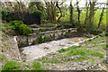
A Tannery settling, washing, or draining tank
Some 'tanks' assumably involved with the original Tannery located in Grampound, the last one closing in 2002. Note that it is situated alongside a small stream so might have been for a washing or draining process for the leather products. The OS Map records it as 'Sluices'
Image: © Mike Lyne
Taken: 12 Apr 2020
0.07 miles
9
Looking Down
Down Grampound's Fore Street past the Market Hall
Image: © Jon Alexander
Taken: 28 Mar 2014
0.07 miles
10
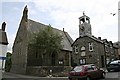
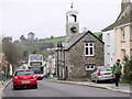
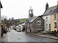
Grampound Church and Town Hall
The town hall is, of course, the building with the clock. It is unusual for a village to have a town hall but Grampound has been around a long time and used to be an important market town and a centre for leather tanning. The church is dedicated to St Nun and was first built in 1370 although the small friendly-looking church you see here dates mainly from a rebuilding of the church in 1869.
Image: © Tony Atkin
Taken: 8 Jul 2006
0.08 miles