IMAGES TAKEN NEAR TO
Grampound, TRURO, TR2 4RW
Introduction
This page details the photographs taken nearby to TR2 4RW by members of the Geograph project.
The Geograph project started in 2005 with the aim of publishing, organising and preserving representative images for every square kilometre of Great Britain, Ireland and the Isle of Man.

There are currently over 7.5m images from over14,400 individuals and you can help contribute to the project by visiting https://www.geograph.org.uk
Image Map
Images are licensed for reuse under creativecommons.org/licenses/by-sa/2.0
Notes
- Clicking on the map will re-center to the selected point.
- The higher the marker number, the further away the image location is from the centre of the postcode.
Image Listing (15 Images Found)
Images are licensed for reuse under creativecommons.org/licenses/by-sa/2.0
Image
Details
Distance
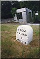
1
Old Milestone by the A390 in Grampound
Carved stone post by the A390, in parish of GRAMPOUND WITH CREED (RESTORMEL District), by public weighbridge, just West of tollhouse, on grass verge, on North side of road. Truro stone, erected by the Truro turnpike trust in the 18th century.
Inscription reads:-
FROM
TRURO
8
MILES
Grade II listed.
List Entry Number: 1396215
Milestone Society National ID: CW_TOSA08
Image: © Paul Barnett
Taken: 23 Jan 2023
0.13 miles
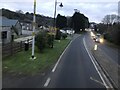
2

On the A390
A390 approaching Grampound.
Image: © Robert Ashby
Taken: 19 Aug 2014
0.13 miles
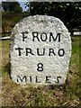
3
Old Milestone by the A390 in Grampound
Carved stone post by the A390, in parish of GRAMPOUND WITH CREED (RESTORMEL District), by public weighbridge, just West of tollhouse, on grass verge, on North side of road. Truro stone, erected by the Truro turnpike trust in the 18th century.
Inscription reads:-
FROM
TRURO
8
MILES
Grade II Listed. List Entry Number:1396215
https://historicengland.org.uk/listing/the-list/list-entry/1396215
Milestone Society National ID: CW_TOSA08.
Image: © Ian Thompson
Taken: 1 Jun 1996
0.15 miles
4
Old Milestone by the A390 in Grampound
Carved stone post by the A390, in parish of GRAMPOUND WITH CREED (RESTORMEL District), by public weighbridge, just West of tollhouse, on grass verge, on North side of road. Truro stone, erected by the Truro turnpike trust in the 18th century.
Inscription reads:-
FROM
TRURO
8
MILES
Grade II listed.
List Entry Number: 1396215 https://historicengland.org.uk/listing/the-list/list-entry/1396215
Milestone Society National ID: CW_TOSA08.
Image: © Rosy Hanns
Taken: 17 Apr 2019
0.15 miles
6

Dead tree beside the lay-by at Trevolland
Decorated with various old buoys and floats.
Image: © Rod Allday
Taken: 8 Apr 2011
0.17 miles
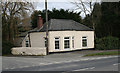
7

Lay-by on the A390 at Trevolland
Originally the route of the road, before re-alignment and improvement. This was the main route from Exeter to Truro, as the road ran through Grampound, the lowest crossing on the River Fal.
Image: © Rod Allday
Taken: 8 Apr 2011
0.17 miles
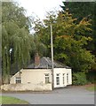
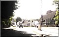
9
Grampound Tollhouse by the A390, Fore Street, Grampound
Tollhouse by the A390, in parish of Grampound with Creed (Restormel District), Toll House, Fore Street, Grampound, TR2 4RX.
Cornwall & Scilly HER.
HER Number: 22980 https://www.heritagegateway.org.uk/Gateway/Results_Single.aspx?uid=MCO26128&resourceID=1020
Surveyed
Milestone Society National ID: CW.GRA02
Image: © Alan Rosevear
Taken: 26 Feb 2009
0.18 miles