IMAGES TAKEN NEAR TO
Grampound, TRURO, TR2 4RH
Introduction
This page details the photographs taken nearby to TR2 4RH by members of the Geograph project.
The Geograph project started in 2005 with the aim of publishing, organising and preserving representative images for every square kilometre of Great Britain, Ireland and the Isle of Man.

There are currently over 7.5m images from over14,400 individuals and you can help contribute to the project by visiting https://www.geograph.org.uk
Image Map
Images are licensed for reuse under creativecommons.org/licenses/by-sa/2.0
Notes
- Clicking on the map will re-center to the selected point.
- The higher the marker number, the further away the image location is from the centre of the postcode.
Image Listing (4 Images Found)
Images are licensed for reuse under creativecommons.org/licenses/by-sa/2.0
Image
Details
Distance
2
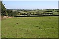
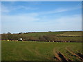
Pasture Land
The tall hedgerow on the left is at the side of the A390 road.
Image: © Tony Atkin
Taken: 15 Sep 2006
0.22 miles
3
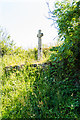
Nancor Cross Monument
Nancor Cross is a Scheduled Monument (as from March 1974). These were part of a network of Christian Crosses erected between the 9th to 15th Century as a reminder of the Christian Churches in the area and to act as a way marker on regularly travelled routes. These tend to be concentrated in Cornwall and Dartmoor but with an estimated 350 across the country in total.
Image: © Mike Lyne
Taken: 2 Jun 2020
0.25 miles
4
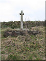
Old Wayside Cross by the A390 near Grampound
Nancor Cross, old head and shaft; Langdon MC No. 26 by the A390, in parish of Grampound with Creed (Restormel District), junction of the road from Nancor and the main Truro Road, high on the bank.
Scheduled Monument.
List Entry Number: 1016284 https://historicengland.org.uk/listing/the-list/list-entry/1016284
Surveyed
Milestone Society National ID: CWRE_GRA02
Image: © Alan Rosevear
Taken: 26 Feb 2009
0.25 miles