IMAGES TAKEN NEAR TO
Fore Street, TRURO, TR2 4QP
Introduction
This page details the photographs taken nearby to Fore Street, TR2 4QP by members of the Geograph project.
The Geograph project started in 2005 with the aim of publishing, organising and preserving representative images for every square kilometre of Great Britain, Ireland and the Isle of Man.

There are currently over 7.5m images from over14,400 individuals and you can help contribute to the project by visiting https://www.geograph.org.uk
Image Map
Images are licensed for reuse under creativecommons.org/licenses/by-sa/2.0
Notes
- Clicking on the map will re-center to the selected point.
- The higher the marker number, the further away the image location is from the centre of the postcode.
Image Listing (41 Images Found)
Images are licensed for reuse under creativecommons.org/licenses/by-sa/2.0
Image
Details
Distance
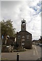
3
Clock Tower, Town Hall, Grampound
View of the clock tower from the pavement below. The cross is a temporary feature over Christmas.
Image: © Dean Jenkins
Taken: 14 Jan 2007
0.01 miles
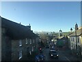
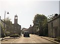
4
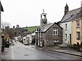
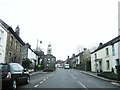
Looking Down
Down Grampound's Fore Street past the Market Hall
Image: © Jon Alexander
Taken: 28 Mar 2014
0.01 miles
6
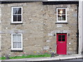
'Bonython Cottage', Grampound, Cornwall
Image: © nick macneill
Taken: 5 Apr 2011
0.02 miles
8
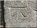
Ordnance Survey Cut Mark with Bolt
This can be found on the Wall of The Market House in Grampound. The benchmark height is recorded as being 33.9922 metres above sea level.
For more detail see : http://www.bench-marks.org.uk/bm45662
Image: © Peter Wood
Taken: 5 May 2017
0.02 miles
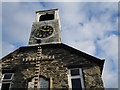
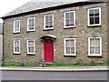
10
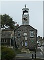
Grampound - Town Hall
The Town Hall (now parish room) with its attractive clock tower probably dates from the early C18th but with C19th and C20th alterations, including the rebuilding of the clock tower in c.1982
It is called the 'town' hall although Grampound is only a village.
It is EH Grade II listed: https://historicengland.org.uk/listing/the-list/list-entry/1144042
In front of it can be seen Image] which is also Grade II listed https://historicengland.org.uk/listing/the-list/list-entry/1136383
Image: © Rob Farrow
Taken: 6 Oct 2021
0.03 miles