IMAGES TAKEN NEAR TO
Ladock, TRURO, TR2 4QB
Introduction
This page details the photographs taken nearby to TR2 4QB by members of the Geograph project.
The Geograph project started in 2005 with the aim of publishing, organising and preserving representative images for every square kilometre of Great Britain, Ireland and the Isle of Man.

There are currently over 7.5m images from over14,400 individuals and you can help contribute to the project by visiting https://www.geograph.org.uk
Image Map
Images are licensed for reuse under creativecommons.org/licenses/by-sa/2.0
Notes
- Clicking on the map will re-center to the selected point.
- The higher the marker number, the further away the image location is from the centre of the postcode.
Image Listing (3 Images Found)
Images are licensed for reuse under creativecommons.org/licenses/by-sa/2.0
Image
Details
Distance
1
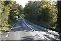
B3275 South of Ladock. Looking south
Until the improvements to the A30 to the north this was the main road between Truro and Bodmin
Image: © Fred James
Taken: 31 Oct 2008
0.07 miles
2
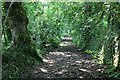
Footpath along the Tresillian River Valley
This footpath runs south from the village of Ladock and follows the western side of the valley flood plain. Caution is required to walk it as wires have been strung across the footpath in various places, presumably by farmers to control stock movement along it.
Image: © Tony Atkin
Taken: 1 Jul 2006
0.14 miles
3
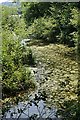
Pond in the Tresillian River Valley
This pond may well have been artificially dug and then abandoned to nature.
Image: © Tony Atkin
Taken: 1 Jul 2006
0.24 miles