IMAGES TAKEN NEAR TO
Ladock, TRURO, TR2 4PS
Introduction
This page details the photographs taken nearby to TR2 4PS by members of the Geograph project.
The Geograph project started in 2005 with the aim of publishing, organising and preserving representative images for every square kilometre of Great Britain, Ireland and the Isle of Man.

There are currently over 7.5m images from over14,400 individuals and you can help contribute to the project by visiting https://www.geograph.org.uk
Image Map
Images are licensed for reuse under creativecommons.org/licenses/by-sa/2.0
Notes
- Clicking on the map will re-center to the selected point.
- The higher the marker number, the further away the image location is from the centre of the postcode.
Image Listing (5 Images Found)
Images are licensed for reuse under creativecommons.org/licenses/by-sa/2.0
Image
Details
Distance
2
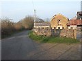
Nankilly Farm and road to Nankilly water
Image: © Fred James
Taken: 11 Apr 2007
0.12 miles
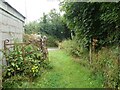
3
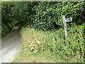
Nankilly - Lane and footpath sign
The lane here continues via Nankilly Water to Downgate while a footpath veers off to the south. See Image] and Image]
Image: © Rob Farrow
Taken: 30 Jul 2022
0.20 miles
4
Nankilly - Old gate at northern end of footpath by Nankilly Farm
A rusting old iron gate lies open at the northern end of the footpath that hugs the eastern side of Image This is the footpath signed in Image]
Image: © Rob Farrow
Taken: 30 Jul 2022
0.20 miles