IMAGES TAKEN NEAR TO
Ladock, TRURO, TR2 4PB
Introduction
This page details the photographs taken nearby to TR2 4PB by members of the Geograph project.
The Geograph project started in 2005 with the aim of publishing, organising and preserving representative images for every square kilometre of Great Britain, Ireland and the Isle of Man.

There are currently over 7.5m images from over14,400 individuals and you can help contribute to the project by visiting https://www.geograph.org.uk
Image Map
Images are licensed for reuse under creativecommons.org/licenses/by-sa/2.0
Notes
- Clicking on the map will re-center to the selected point.
- The higher the marker number, the further away the image location is from the centre of the postcode.
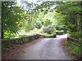
Image Listing (5 Images Found)
Images are licensed for reuse under creativecommons.org/licenses/by-sa/2.0
Image
Details
Distance
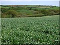
1
View to the north of Nansough Farm
The countryside of the area north of Truro.
Image: © Jonathan Billinger
Taken: 2 Oct 2007
0.08 miles
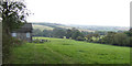
2
Fresh new growth near Nansough Barton
Recently seeded pasture.
Image: © Rod Allday
Taken: 3 Oct 2009
0.12 miles
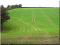
4
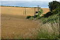
Farmland, Ladock
Wheat beside the footpath between Nansough and Treverbyn.
Image: © Andrew Smith
Taken: 5 Jul 2023
0.21 miles