IMAGES TAKEN NEAR TO
Pras Park An Ger, TR2 4JQ
Introduction
This page details the photographs taken nearby to Pras Park An Ger, TR2 4JQ by members of the Geograph project.
The Geograph project started in 2005 with the aim of publishing, organising and preserving representative images for every square kilometre of Great Britain, Ireland and the Isle of Man.

There are currently over 7.5m images from over14,400 individuals and you can help contribute to the project by visiting https://www.geograph.org.uk
Image Map
Images are licensed for reuse under creativecommons.org/licenses/by-sa/2.0
Notes
- Clicking on the map will re-center to the selected point.
- The higher the marker number, the further away the image location is from the centre of the postcode.
Image Listing (13 Images Found)
Images are licensed for reuse under creativecommons.org/licenses/by-sa/2.0
Image
Details
Distance
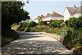
4
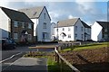
Houses, Probus
Rosva Wenton, part of a new development on the south-eastern edge of the village.
Image: © Andrew Smith
Taken: 12 Nov 2019
0.16 miles
6
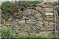
Traditional stone walling in Probus Garden
Probus Garden was built by Cornwall County Council in 1969 as a nationally recognised demonstration garden.
Image: © Stuart Logan
Taken: Unknown
0.17 miles
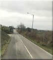
9
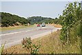
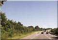
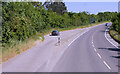
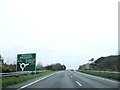
The Main Road between Truro and St Austell
This is the A390, photographed where it bypasses Probus to the south.
Image: © Tony Atkin
Taken: 1 Jul 2006
0.23 miles
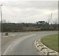
10
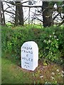
Old Milestone by the former A390, east of Probus
Carved stone post by the A390, in parish of PROBUS (CARRICK District), opposite entrance to Probus Gardens, at top of hill, on North side of road. Truro stone, erected by the Truro turnpike trust in the 18th century.
Inscription reads:-
FROM
TRURO
6
MILES
Carved benchmark on front face.
Grade II Listed. List Entry Number:1396160
https://historicengland.org.uk/listing/the-list/list-entry/1396160
Milestone Society National ID: CW_TOSA06.
Image: © Ian Thompson
Taken: 1 Jun 1996
0.23 miles