IMAGES TAKEN NEAR TO
Probus, TRURO, TR2 4JF
Introduction
This page details the photographs taken nearby to TR2 4JF by members of the Geograph project.
The Geograph project started in 2005 with the aim of publishing, organising and preserving representative images for every square kilometre of Great Britain, Ireland and the Isle of Man.

There are currently over 7.5m images from over14,400 individuals and you can help contribute to the project by visiting https://www.geograph.org.uk
Image Map
Images are licensed for reuse under creativecommons.org/licenses/by-sa/2.0
Notes
- Clicking on the map will re-center to the selected point.
- The higher the marker number, the further away the image location is from the centre of the postcode.
Image Listing (5 Images Found)
Images are licensed for reuse under creativecommons.org/licenses/by-sa/2.0
Image
Details
Distance
1
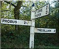
Old Direction Sign - Signpost south of Levardro
Pyramid finial - 3 arms; by the UC road, in parish of Probus (Carrick District), by crossroads South of Levardro, on the verge.
To be surveyed
Milestone Society National ID: CW_SW8748
Image: © Milestone Society
Taken: Unknown
0.12 miles
3
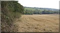
Stubble field south of Levardo
View south down the valley towards Truro.
Image: © Jonathan Billinger
Taken: 2 Oct 2007
0.14 miles
4
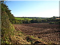
Field at Levardro
This photo was taken two years and one week later than Jonathan Billinger's Image, when the stubble was awaiting ploughing. Here it has been ploughed and tilled.
Image: © Rod Allday
Taken: 8 Oct 2009
0.15 miles