IMAGES TAKEN NEAR TO
Rew Helygen, TRURO, TR2 4FJ
Introduction
This page details the photographs taken nearby to Rew Helygen, TR2 4FJ by members of the Geograph project.
The Geograph project started in 2005 with the aim of publishing, organising and preserving representative images for every square kilometre of Great Britain, Ireland and the Isle of Man.

There are currently over 7.5m images from over14,400 individuals and you can help contribute to the project by visiting https://www.geograph.org.uk
Image Map
Images are licensed for reuse under creativecommons.org/licenses/by-sa/2.0
Notes
- Clicking on the map will re-center to the selected point.
- The higher the marker number, the further away the image location is from the centre of the postcode.
Image Listing (6 Images Found)
Images are licensed for reuse under creativecommons.org/licenses/by-sa/2.0
Image
Details
Distance
1
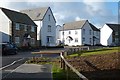
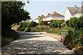
Houses, Probus
Rosva Wenton, part of a new development on the south-eastern edge of the village.
Image: © Andrew Smith
Taken: 12 Nov 2019
0.04 miles
2
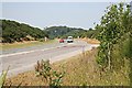
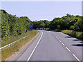
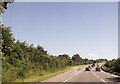
The Main Road between Truro and St Austell
This is the A390, photographed where it bypasses Probus to the south.
Image: © Tony Atkin
Taken: 1 Jul 2006
0.11 miles
4
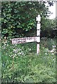
Direction Sign - Signpost by Wakeham's Grave, Probus parish
No finial - by the UC road, in parish of Probus (Carrick District), Wakeham's Grave, at crossroads made defunct by Probus by-pass.
Cornwall & Scilly HER.
HER Number: MCO54656 https://www.heritagegateway.org.uk/Gateway/Results_Single.aspx?uid=MCO54656&resourceID=1020
To be surveyed
Milestone Society National ID: CW_SW9046
Image: © Milestone Society
Taken: Unknown
0.17 miles