IMAGES TAKEN NEAR TO
Grampound Road, TRURO, TR2 4EL
Introduction
This page details the photographs taken nearby to TR2 4EL by members of the Geograph project.
The Geograph project started in 2005 with the aim of publishing, organising and preserving representative images for every square kilometre of Great Britain, Ireland and the Isle of Man.

There are currently over 7.5m images from over14,400 individuals and you can help contribute to the project by visiting https://www.geograph.org.uk
Image Map
Images are licensed for reuse under creativecommons.org/licenses/by-sa/2.0
Notes
- Clicking on the map will re-center to the selected point.
- The higher the marker number, the further away the image location is from the centre of the postcode.
Image Listing (6 Images Found)
Images are licensed for reuse under creativecommons.org/licenses/by-sa/2.0
Image
Details
Distance
1
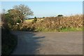
Entrance to Carnemough Farm
Also the entrance to Seaview Recovery, a metal recycling plant. This is off the road north of Grampound Road.
Image: © Derek Harper
Taken: 23 Jan 2017
0.05 miles
2
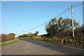
Road past Carnemough Farm
From where Image] was taken, looking along the road to Scarcewater, followed by the parish boundary between Ladock (left) and Sr Stephen-in-Brannel.
Image: © Derek Harper
Taken: 23 Jan 2017
0.06 miles
3
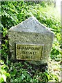
Old Milestone north of Grampound Road
Stone post (replacement plates) by the UC road, in parish of LADOCK (CARRICK District), opposite drive to Carnemough Farm, by the road, on East side of road. Erected by the Local Highways Board in the 19th century.
Inscription reads:-
: GRAMPOUND / ROAD / 1 MILE : : BLUE / ANCHOR / 4 MILES :
Carved benchmark and rivet on top.
Cornwall & Scilly HER.
HER Number: 177606 https://www.heritagegateway.org.uk/Gateway/Results_Single.aspx?uid=MCO53392&resourceID=1020
Milestone Society National ID: CW_SWGP03
Image: © Rosy Hanns
Taken: 13 Apr 2019
0.09 miles
4
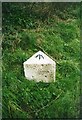
Old Milestone north of Grampound Road
Carved stone post (plates lost) by the UC road, in parish of LADOCK (CARRICK District), opposite drive to Carnemough Farm, by the road, on East side of road. Erected by the Local Highways Board in the 19th century.
Inscription once read:-
: (GRAMPOUND / ROAD / 1 MILE) : : (BLUE / ANCHOR / 4 MILES) :
Carved bench mark on top.
Milestone Society National ID: CW_SWGP03.
Image: © Ian Thompson
Taken: 1 Jan 1998
0.09 miles
5
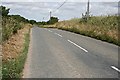
Along the road
This unnumbered C class road has traffic and a width more like a B road. It runs straight north to south for quite a distance through this part of mid Cornwall.
Image: © Tony Atkin
Taken: 8 Jul 2006
0.14 miles
6
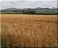
Ripening Barley Field
In the distance is a fine view of the 'Cornish Alps' the spoil heaps from the china clay industry on the St Austell granite.
Image: © Tony Atkin
Taken: 8 Jul 2006
0.15 miles