IMAGES TAKEN NEAR TO
Grampound Road, TRURO, TR2 4EH
Introduction
This page details the photographs taken nearby to TR2 4EH by members of the Geograph project.
The Geograph project started in 2005 with the aim of publishing, organising and preserving representative images for every square kilometre of Great Britain, Ireland and the Isle of Man.

There are currently over 7.5m images from over14,400 individuals and you can help contribute to the project by visiting https://www.geograph.org.uk
Image Map
Images are licensed for reuse under creativecommons.org/licenses/by-sa/2.0
Notes
- Clicking on the map will re-center to the selected point.
- The higher the marker number, the further away the image location is from the centre of the postcode.
Image Listing (24 Images Found)
Images are licensed for reuse under creativecommons.org/licenses/by-sa/2.0
Image
Details
Distance
1
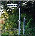
Old Direction Sign - Signpost by Trenowth, Ladock parish
Ball finial - 3D pointing hand; Charlestown by the UC road, in parish of Ladock (Carrick District), turning to Trenowth residential barns, on bank.
Surveyed
Milestone Society National ID: CW_SW9350
Image: © Milestone Society
Taken: Unknown
0.03 miles
2
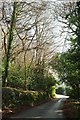
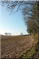
Lane, Trenowth
From the same spot as Image, looking right.
Image: © Derek Harper
Taken: 23 Jan 2017
0.03 miles
3
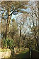
Drive to Trenowth House
From the lane from Grampound Road.
Image: © Derek Harper
Taken: 23 Jan 2017
0.06 miles
4
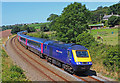
Railway at Trenowth
Passenger train passing the farm at Trenowth.
Image: © Wayland Smith
Taken: 25 Jul 2012
0.08 miles
5
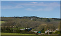
Trenowth House from a distance
Trenowth House in Trenowth Woods between Grampound Road and Coombe across fields from above Higher Tevillick Farm on Pepo Lane.
Image: © Mike Lyne
Taken: 13 Apr 2020
0.09 miles
7
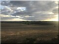
Field, Trenowth
From beside the spot where Image] and Image] were taken, with trees alongside the railway line on the right.
Image: © Derek Harper
Taken: 23 Jan 2017
0.10 miles
8
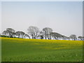
Field at Trenowth
I'm not sure what the yellow haze is - buttercups, dandelions or charlock possibly? The line of trees is along the footpath from Trenowth to Benallack,
Image: © Rod Allday
Taken: 8 Apr 2011
0.12 miles
9
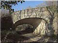
Railway bridge, Trenowth
A slightly different angle on the bridge shown in Image
Image: © Derek Harper
Taken: 23 Jan 2017
0.13 miles
10
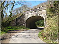
Railway bridge at Trenowth
Carrying the Paddington-Penzance main line.
Image: © Rod Allday
Taken: 8 Apr 2011
0.14 miles